Geolocate

Hobart topographic map

Interactive map

Click on the map to display elevation.

About this map

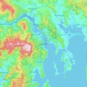
Name: Hobart topographic map, elevation, terrain.

Location: Hobart, City of Hobart, Tasmania, Australia (-43.10362 147.09169 -42.65538 147.64559)

Average elevation: 179 m

Minimum elevation: -2 m

Maximum elevation: 1,260 m

Although Hobart itself rarely receives snow during the winter due to the foehn effect created by the Central Highlands (the city's geographic position causes a rain shadow), the adjacent Kunanyi/Mount Wellington is frequently seen with a snowcap throughout the year including in summer. During the 20th century, the city itself has received snowfalls at sea level on average only once every 5 years; however, outer suburbs lying higher on the slopes of Mount Wellington receive snow more often, owing to the more exposed position coupled with them resting at higher altitude. These snow-bearing winds often carry on through Tasmania and Victoria to the Snowy Mountains in Victoria and southern New South Wales.

Wikipedia (CC-BY-SA 3.0)

Other topographic maps

Click on a map to view its topography, its elevation and its terrain.

Launceston

Australia > Tasmania

Launceston, City of Launceston, Tasmania, Australia

Average elevation: 194 m

Queenstown

Australia > Tasmania

Queenstown, West Coast, Tasmania, 7467, Australia

Average elevation: 330 m

Deloraine

Australia > Tasmania > Deloraine

Deloraine, Meander Valley, Tasmania, 7304, Australia

Average elevation: 274 m

Fern Tree

Australia > Tasmania > Hobart

Fern Tree, Hobart, City of Hobart, Tasmania, Australia

Average elevation: 404 m

Campbell Town

Australia > Tasmania > Campbell Town

Campbell Town, Northern Midlands, Tasmania, 7210, Australia

Average elevation: 345 m

Exeter

Australia > Tasmania > Exeter

Exeter, West Tamar, Tasmania, Australia

Average elevation: 70 m

Clarence Point

Australia > Tasmania > Clarence Point

Clarence Point, West Tamar, Tasmania, Australia

Average elevation: 13 m

Legana

Australia > Tasmania > Launceston > Legana

Legana, Launceston, West Tamar, Tasmania, Australia

Average elevation: 82 m

Hobart

Australia > Tasmania > Hobart

Hobart, City of Hobart, Tasmania, Australia

Average elevation: 31 m

Mount Nelson

Australia > Tasmania > Hobart

Mount Nelson, Hobart, City of Hobart, Tasmania, Australia

Average elevation: 198 m

Mount Arrowsmith

Australia > Tasmania

Mount Arrowsmith, Tasmania, Australia

Average elevation: 761 m

Flinders Island

Australia > Tasmania

Flinders Island, Tasmania, Australia

Average elevation: 20 m

Hartz Mountains

Australia > Tasmania

Hartz Mountains, Tasmania, Australia

Average elevation: 931 m

Babel Island

Australia > Tasmania

Babel Island, Tasmania, Australia

Average elevation: 27 m

Macquarie

Australia > Tasmania

Macquarie, Tasmania, Australia

Average elevation: 20 m

Hobart

Australia > Tasmania > Hobart

Hobart, Tasmania, Australia

Average elevation: 31 m

Snowy Range

Australia > Tasmania

Snowy Range, Tasmania, Australia

Average elevation: 670 m