
Make a donation
New South Wales topographic map
Click on the map to display elevation.
Make a donation
New South Wales
New South Wales (NSW), located on Australia's eastern seaboard, boasts a diverse topography that significantly influences its landscapes and ecosystems. The state's eastern edge is dominated by a narrow coastal plain, featuring regions such as the Illawarra and Shoalhaven near Nowra, characterized by rolling hills and valleys. This coastal strip is flanked to the west by the Great Dividing Range, a series of mountain ranges, plateaus, and upland areas that extend over 3,500 kilometers (2,175 miles) along Australia's eastern coast. Within NSW, this range includes notable sections like the Blue Mountains, Southern Highlands, Central Tablelands, and Northern Tablelands, with many peaks exceeding 1,000 meters (3,281 feet) in elevation. The state's highest point, Mount Kosciuszko, rises to 2,228 (7,310 feet) meters within the Snowy Mountains, part of the Great Dividing Range. Westward, the terrain transitions into expansive agricultural plains, such as the Riverina region around Wagga Wagga, characterized by fertile soils and open landscapes. Further west, the Western Plains encompass nearly two-thirds of NSW, presenting arid to semi-arid conditions with vast, flat expanses and sparse vegetation.
Make a donation
About this map
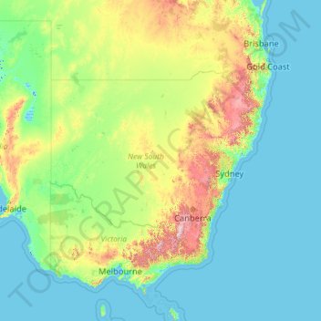
Name: New South Wales topographic map, elevation, terrain.
Location: New South Wales, Australia (-37.52801 140.99927 -28.14153 159.33903)
Average elevation: 154 m
Minimum elevation: -6 m
Maximum elevation: 2,129 m
Make a donation
Other topographic maps
Click on a map to view its topography, its elevation and its terrain.
Make a donation
Canberra
The area chosen for the capital had been inhabited by Aboriginal Australians for up to 21,000 years, by groups including the Ngunnawal and Ngambri. European settlement commenced in the first half of the 19th century, as evidenced by surviving landmarks such as St John's Anglican Church and Blundells Cottage.…
Average elevation: 638 m
Make a donation
Make a donation
Make a donation
Make a donation