
Tlaxcala topographic map
Interactive map
Click on the map to display elevation.
About this map
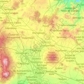
Name: Tlaxcala topographic map, elevation, terrain.
Location: Tlaxcala, Mexico (19.10507 -98.70840 19.72892 -97.62544)
Average elevation: 2,540 m
Minimum elevation: 1,279 m
Maximum elevation: 5,328 m
Tlaxcala is a land-locked state situated on the Trans-Mexican Volcanic Belt. The average altitude for the state is 2,230 meters above sea level, making it a bit higher than the Valley of Mexico just to the southwest. The western part of the state lies on the central plateau of Mexico while the east is dominated by the Sierra Madre Oriental, home of the 4,461 meter La Malinche volcano. Most of the state is rugged terrain dominated by ridges and deep valleys, along with protruding igneous rock formations. This ruggedness, along with large-scale weather phenomena such as the Intertropical Convergence Zone, gives the state a complex climate. Overall rain patterns for the state are about 400 mm (16 in) in the summer rainy season and 30 mm (1.2 in) in the winter. Locally, however, this varies dramatically between the drier plateaus and valleys and the wetter mountains. Variations in altitude produce sub-climates between semi-tropical to temperate, with frosts likely in the higher elevations during the winter. Temperate forests of pine, fir (Abies religiosa), evergreen oak (Quercus ilex) and junipers (Juniperus communis) dominate the mountain highlands while the flatlands, with their drier climate, are characterized by agaves and prickly pear cactus (Opuntia).
Other topographic maps
Click on a map to view its topography, its elevation and its terrain.
San José el Verde
San José el Verde, El Salto, Región Centro, Jalisco, 45694, Mexico
Average elevation: 1,551 m
San Felipe
Mexico > Baja California > Municipio de San Felipe
San Felipe, Municipio de San Felipe, Baja California, 21079, Mexico
Average elevation: 34 m
La Casa de Piedra
Mexico > Sonora > Villa Hidalgo
La Casa de Piedra, Villa Hidalgo, Sonora, Mexico
Average elevation: 726 m
Acapulco
Mexico > Guerrero > Acapulco de Juárez
Acapulco, Acapulco de Juárez, Guerrero, 39300, Mexico
Average elevation: 99 m
San Quintín
Mexico > Baja California > Municipio de San Quintín
San Quintín, Municipio de San Quintín, Baja California, 22932, Mexico
Average elevation: 36 m
Tepetiltic
Mexico > Nayarit > San Pedro Lagunillas
Tepetiltic, San Pedro Lagunillas, Nayarit, Mexico
Average elevation: 1,520 m
Naucalpan de Juárez
Naucalpan de Juárez, State of Mexico, Mexico
Average elevation: 2,366 m
Nezahualcóyotl
Nezahualcóyotl, State of Mexico, Mexico
Average elevation: 2,235 m
Malibu
Mexico > Chiapas > Tuxtla Gutiérrez > Terán
Malibu, Terán, Tuxtla Gutiérrez, Chiapas, 29025, Mexico
Average elevation: 645 m
Santa Rosa Jauregui
Mexico > Querétaro > Municipio de Querétaro
Santa Rosa Jauregui, Municipio de Querétaro, Querétaro, Mexico
Average elevation: 1,979 m
Villa del Río
Mexico > Veracruz > Manlio Fabio Altamirano
Villa del Río, Manlio Fabio Altamirano, Veracruz, Mexico
Average elevation: 45 m
Santa Maria
Mexico > Chihuahua > Namiquipa > El Terrero
Santa Maria, El Terrero, Namiquipa, Chihuahua, Mexico
Average elevation: 1,936 m
Durango
Mexico > Durango > Municipio de Durango > Durango
Durango, Municipio de Durango, Durango, Mexico
Average elevation: 1,936 m
Lázaro Cárdenas
Mexico > Michoacán > Lázaro Cárdenas > Lázaro Cárdenas
Lázaro Cárdenas, Michoacán, 60950, Mexico
Average elevation: 42 m
Matamoros
Mexico > Tamaulipas > Matamoros
Matamoros, Municipio de Matamoros, Tamaulipas, 87457, Mexico
Average elevation: 9 m
San Juan la Unión
Mexico > Oaxaca > San Lucas Zoquiápam
San Juan la Unión, San Lucas Zoquiápam, Oaxaca, Mexico
Average elevation: 1,750 m
Ensenada
Mexico > Baja California > Municipio de Ensenada
Ensenada, Municipio de Ensenada, Baja California, Mexico
Average elevation: 184 m
Rincón de Romos
Mexico > Aguascalientes > Rincón de Romos
Rincón de Romos, Aguascalientes, 20603, Mexico
Average elevation: 1,981 m
Ecatepec de Morelos
Ecatepec de Morelos, State of Mexico, Mexico
Average elevation: 2,288 m
Cabo San Lucas
Mexico > South Lower California > Cabo San Lucas
Cabo San Lucas, Los Cabos, South Lower California, 23470, Mexico
Average elevation: 94 m
Tlaltenango de Sánchez Román
Tlaltenango de Sánchez Román, Zacatecas, Mexico
Average elevation: 2,037 m
Puerto Vallarta
Mexico > Jalisco > Puerto Vallarta
Puerto Vallarta, Jalisco, 48300, Mexico
Average elevation: 306 m