
Birecik topographic map
Interactive map
Click on the map to display elevation.
About this map
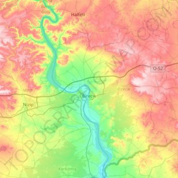
Name: Birecik topographic map, elevation, terrain.
Location: Birecik, Şanlıurfa, Südostanatolien, 63400, Türkei (36.83034 37.86334 37.26637 38.35192)
Average elevation: 552 m
Minimum elevation: 325 m
Maximum elevation: 853 m
Other topographic maps
Click on a map to view its topography, its elevation and its terrain.
Yozgat
Yozgat, Yozgat Merkez, Yozgat, Zentralanatolien, 66100, Türkei
Average elevation: 1,250 m
Cennetpınarı
Türkei > Türkoğlu > Cennetpınarı
Cennetpınarı, Türkoğlu, Kahramanmaraş, Mittelmeerregion, 46800, Türkei
Average elevation: 628 m
Ararat
Ararat, Iğdır Merkez, Iğdır, Ostanatolien, Türkei
Average elevation: 4,582 m
İzmit
Türkei > Marmararegion > İzmit
İzmit, Kocaeli, Marmararegion, 41300, Türkei
Average elevation: 290 m