
Ağrı Merkez topographic map
Interactive map
Click on the map to display elevation.
About this map
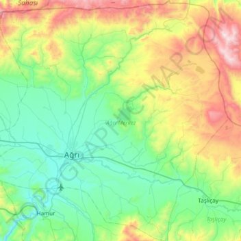
Name: Ağrı Merkez topographic map, elevation, terrain.
Location: Ağrı Merkez, Ağrı, Ostanatolien, Türkei (39.55825 42.85590 40.00230 43.42733)
Average elevation: 2,016 m
Minimum elevation: 1,581 m
Maximum elevation: 3,228 m
Other topographic maps
Click on a map to view its topography, its elevation and its terrain.
Yozgat
Yozgat, Yozgat Merkez, Yozgat, Zentralanatolien, 66100, Türkei
Average elevation: 1,250 m
Cennetpınarı
Türkei > Türkoğlu > Cennetpınarı
Cennetpınarı, Türkoğlu, Kahramanmaraş, Mittelmeerregion, 46800, Türkei
Average elevation: 628 m
Ararat
Ararat, Iğdır Merkez, Iğdır, Ostanatolien, Türkei
Average elevation: 4,582 m
İzmit
Türkei > Marmararegion > İzmit
İzmit, Kocaeli, Marmararegion, 41300, Türkei
Average elevation: 290 m