
Çankırı topographic map
Interactive map
Click on the map to display elevation.
About this map
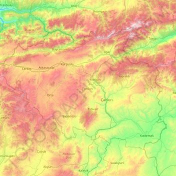
Name: Çankırı topographic map, elevation, terrain.
Location: Çankırı, Zentralanatolien, Türkei (40.24933 32.56528 41.09713 34.16569)
Average elevation: 1,133 m
Minimum elevation: 290 m
Maximum elevation: 2,542 m
Other topographic maps
Click on a map to view its topography, its elevation and its terrain.
Yozgat
Yozgat, Yozgat Merkez, Yozgat, Zentralanatolien, 66100, Türkei
Average elevation: 1,250 m
Cennetpınarı
Türkei > Türkoğlu > Cennetpınarı
Cennetpınarı, Türkoğlu, Kahramanmaraş, Mittelmeerregion, 46800, Türkei
Average elevation: 628 m
Ararat
Ararat, Iğdır Merkez, Iğdır, Ostanatolien, Türkei
Average elevation: 4,582 m
İzmit
Türkei > Marmararegion > İzmit
İzmit, Kocaeli, Marmararegion, 41300, Türkei
Average elevation: 290 m