
Aksaray topographic map
Interactive map
Click on the map to display elevation.
About this map
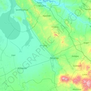
Name: Aksaray topographic map, elevation, terrain.
Location: Aksaray, Zentralanatolien, Türkei (37.97991 33.17463 39.05093 34.50061)
Average elevation: 1,120 m
Minimum elevation: 842 m
Maximum elevation: 3,203 m
Other topographic maps
Click on a map to view its topography, its elevation and its terrain.
Yozgat
Yozgat, Yozgat Merkez, Yozgat, Zentralanatolien, 66100, Türkei
Average elevation: 1,250 m
Cennetpınarı
Türkei > Türkoğlu > Cennetpınarı
Cennetpınarı, Türkoğlu, Kahramanmaraş, Mittelmeerregion, 46800, Türkei
Average elevation: 628 m
Ararat
Ararat, Iğdır Merkez, Iğdır, Ostanatolien, Türkei
Average elevation: 4,582 m
İzmit
Türkei > Marmararegion > İzmit
İzmit, Kocaeli, Marmararegion, 41300, Türkei
Average elevation: 290 m