
Gambela Region topographic map
Interactive map
Click on the map to display elevation.
About this map
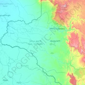
Name: Gambela Region topographic map, elevation, terrain.
Location: Gambela Region, Ethiopia (6.99761 32.99758 8.70993 35.39308)
Average elevation: 702 m
Minimum elevation: 397 m
Maximum elevation: 3,164 m
Anuak zone is by far the largest of the zones of Gambela Region and also includes the capital, Gambela. The terrain is mostly flat at elevations between 400 – 550 meters above sea level but with the eastern fringes of Anuak zone and in particular the easternmost zone, Mezhenger, being partly in the highlands and going up to an elevation of ~2000 meters near the eastern border.
Other topographic maps
Click on a map to view its topography, its elevation and its terrain.
Addis Ababa
Ethiopia > Addis Ababa > Arada
Addis Ababa, Arada, Addis Ababa, 3578, Ethiopia
Average elevation: 2,517 m
North Gondar
North Gondar, Amhara Region, 6200, Ethiopia
Average elevation: 1,440 m
Ankober
Ankober, North Shewa (Amhara Region), Amhara Region, Ethiopia
Average elevation: 2,672 m
Fiche
Fiche, North Shewa (Oromia Region), Oromia Region, Ethiopia
Average elevation: 2,760 m
Butajira
Ethiopia > Southern Nations, Nationalities, and Peoples
Butajira, Guraghe, Southern Nations, Nationalities, and Peoples, Ethiopia
Average elevation: 2,078 m
Mechi
Ethiopia > Oromia Region > Mechi
Mechi, Jimma, Oromia Region, Ethiopia
Average elevation: 1,482 m
Blue Nile
Blue Nile, South Gonder, Amhara Region, Ethiopia
Average elevation: 1,649 m
Ahmar Mountains
Ahmar Mountains, West Harerghe, Oromia Region, Ethiopia
Average elevation: 1,777 m