
Mek'elē topographic map
Interactive map
Click on the map to display elevation.
About this map
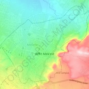
Name: Mek'elē topographic map, elevation, terrain.
Location: Mek'elē, Tigray, Ethiopia (13.47492 39.44380 13.53166 39.51051)
Average elevation: 2,090 m
Minimum elevation: 1,969 m
Maximum elevation: 2,330 m
Mekelle (Tigrinya: መቐለ, Amharic: መቀሌ, romanized: mäqälle, mek’elē) or Mekele is a special zone and capital of the Tigray Region of Ethiopia. Mekelle was formerly the capital of Enderta awraja in Tigray. It is located around 780 kilometres (480 mi) north of the Ethiopian capital Addis Ababa, with an elevation of 2,254 metres (7,395 ft) above sea level. Administratively, Mekelle is considered a Special Zone, which is divided into seven sub-cities. It is the economic, cultural, and political hub of northern Ethiopia.