
Fiche topographic map
Interactive map
Click on the map to display elevation.
About this map
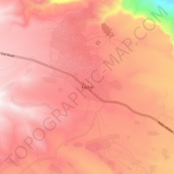
Name: Fiche topographic map, elevation, terrain.
Location: Fiche, North Shewa (Oromia Region), Oromia Region, Ethiopia (9.73196 38.69886 9.81196 38.77886)
Average elevation: 2,760 m
Minimum elevation: 1,860 m
Maximum elevation: 3,093 m
Fiche is a town in central Ethiopia. It is the administrative centre of the Kaba Shewa Zone of Oromia and separate District. It is located about three km from the main Addis Ababa-Debre Marqos road, Fiche has a latitude and longitude of 9°48′N 38°44′E / 9.800°N 38.733°E / 9.800; 38.733 and an elevation between 2,738 and 2,782 metres above sea level.
Other topographic maps
Click on a map to view its topography, its elevation and its terrain.
Mechi
Ethiopia > Oromia Region > Mechi
Mechi, Jimma, Oromia Region, Ethiopia
Average elevation: 1,482 m
Ahmar Mountains
Ahmar Mountains, West Harerghe, Oromia Region, Ethiopia
Average elevation: 1,777 m