
Ankober topographic map
Interactive map
Click on the map to display elevation.
About this map
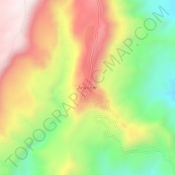
Name: Ankober topographic map, elevation, terrain.
Location: Ankober, North Shewa (Amhara Region), Amhara Region, Ethiopia (9.57115 39.71382 9.61115 39.75382)
Average elevation: 2,672 m
Minimum elevation: 2,185 m
Maximum elevation: 3,183 m
Ankober (Amharic: አንኮበር), formerly known as Ankobar, is a town in central Ethiopia. Located in the North Shewa Zone of the Amhara Region, it's perched on the eastern escarpment of the Ethiopian Highlands at an elevation of about 2,465 meters (8,100 ft). It is 40 kilometers (25 mi) to the east of Debre Birhan and about 90 miles (140 km) northeast of Addis Ababa.
Other topographic maps
Click on a map to view its topography, its elevation and its terrain.
North Gondar
North Gondar, Amhara Region, 6200, Ethiopia
Average elevation: 1,440 m
Blue Nile
Blue Nile, South Gonder, Amhara Region, Ethiopia
Average elevation: 1,649 m