
Make a donation
Tbilisi topographic map
Click on the map to display elevation.
Make a donation
Tbilisi
Most of the raions are named after historic quarters of the city. The citizens of Tbilisi widely recognise an informal system of smaller historic neighbourhoods. Such neighbourhoods are several, however, constituting a kind of hierarchy, because most of them have lost their distinctive topographic limits. The natural first level of subdivision of the city is into the Right Bank and the Left Bank of the Mt'k'vari.
Make a donation
About this map
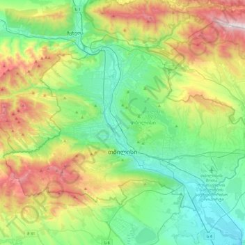
Name: Tbilisi topographic map, elevation, terrain.
Location: Tbilisi, Georgia (41.61779 44.59620 41.84388 45.01729)
Average elevation: 756 m
Minimum elevation: 330 m
Maximum elevation: 1,713 m
Make a donation
Other topographic maps
Click on a map to view its topography, its elevation and its terrain.
Caucasus Mountains
Georgia > Mtskheta-Mtianeti > Dusheti Municipality > Chalisopeli
The climate of the Caucasus varies both vertically (according to elevation) and horizontally (by latitude and location). Temperature generally decreases as elevation rises. Average annual temperature in Sukhumi, Abkhazia at sea level is 15 °C (59 °F) while on the slopes of Mt.Kazbek at an elevation of 3,700…
Average elevation: 2,188 m
Darial Gorge
Georgia > Mtskheta-Mtianeti > Kazbegi Municipality
The Russian fort, Darial, which guarded this section of the Georgian Military Road, was built at the northern end of the gorge, at an altitude of 1,447 metres (4,747 ft).
Average elevation: 1,783 m
Make a donation
Jvari
Georgia > Samegrelo-Upper Svaneti > Tsalenjikha Municipality
Jvari (Georgian: ჯვარი) is a town in the northwestern Georgian province of Samegrelo-Zemo Svaneti. The town is situated at an altitude of 280 metres near the Magana River where it flows into the Enguri River; The town is divided in two with "Jvari" lying on the Zugdidi-Mestia highway, and Jvarzeni…
Average elevation: 450 m
Make a donation
Kveda Sairme
Georgia > Racha-Lechkhumi and Kvemo Svaneti > Tsageri Municipality
Average elevation: 669 m
Gudauri
Georgia > Mtskheta-Mtianeti > Kazbegi Municipality
Gudauri (Georgian: გუდაური) is a ski resort located on the south-facing plateau of The Greater Caucasus Mountain Range in Georgia. The resort is situated in the Stepantsminda District, along the Georgian Military Highway near the Jvari Pass, at an elevation of 2,200 meters (7,200 ft.) above sea…
Average elevation: 2,161 m
Make a donation
Make a donation
Senaki
Georgia > Samegrelo-Upper Svaneti > Senaki Municipality
Senaki (Georgian: სენაკი, senak'i; Mingrelian: სანაკი, sanak'i) is a city in Samegrelo-Zemo Svaneti region, western Georgia. It is located at around 42°16′8″N 42°4′45″E / 42.26889°N 42.07917°E / 42.26889; 42.07917 between the rivers Tekhura/i and Tsivi, at an…
Average elevation: 80 m
Make a donation
Make a donation
Bakuriani
Georgia > Samtskhe-Javakheti > Borjomi Municipality
Bakuriani (Georgian: ბაკურიანი) is a daba and a ski resort in the Borjomi district of Georgia. It is located on the northern slope of the Trialeti Range, at an elevation of 1,700 meters (5,576 feet) above sea level.
Average elevation: 1,756 m
Make a donation
Make a donation
Kveda Tkhilvana
Georgia > Autonomous Republic of Adjara > Khulo Municipality
Average elevation: 1,635 m
Make a donation
Very steep, dangerous route
Georgia > Samegrelo-Upper Svaneti > Mestia Municipality
Average elevation: 1,875 m
Make a donation
Make a donation
Tbilisa Glacier
Georgia > Racha-Lechkhumi and Kvemo Svaneti > Oni Municipality
Average elevation: 3,443 m
Make a donation
Shan
Georgia > Mtskheta-Mtianeti > Kazbegi Municipality
Mt. Shani (Ingush: Шанлоам, lit. ''icy mountain''; Georgian: შანი; Russian: Шан) also known as Shan and Shanloam is a mountain in the Caucasus. It has an elevation of 4,451 metres (14,603 ft) and is on the international border between Georgia and Ingushetia, Russia.
Average elevation: 3,620 m
Make a donation
Make a donation
Caucasus Mountains
Georgia > Mtskheta-Mtianeti > Dusheti Municipality > Chalisopeli
The climate of the Caucasus varies both vertically (according to elevation) and horizontally (by latitude and location). Temperature generally decreases as elevation rises. Average annual temperature in Sokhumi, Abkhazia at sea level is 15 °C (59 °F) while on the slopes of Mt.Kazbek at an elevation of 3,700…
Average elevation: 2,188 m
Mestia
Georgia > Samegrelo-Upper Svaneti > Mestia Municipality
Mestia (Georgian: მესტია IPA: [mestʼia]) is a highland townlet (daba) in northwest Georgia, at an elevation of 1,500 metres (4,921 feet) in the Caucasus Mountains.
Average elevation: 1,761 m
Make a donation
Mtirala
Georgia > Autonomous Republic of Adjara > Khelvachauri Municipality
Average elevation: 1,000 m
Bakuriani
Georgia > Samtskhe-Javakheti > Borjomi Municipality
Bakuriani (Georgian: ბაკურიანი) is a daba and a ski resort in the Borjomi district of Georgia. It is located on the northern slope of the Trialeti Range, at an elevation of 1,700 meters (5,576 feet) above sea level.
Average elevation: 1,756 m
Make a donation
Shaori Reservoir
Georgia > Racha-Lechkhumi and Kvemo Svaneti > Ambrolauri Municipality > Kharistvala
Average elevation: 1,281 m
Gudauri
Georgia > Mtskheta-Mtianeti > Kazbegi Municipality
Gudauri (Georgian: გუდაური) is a ski resort located on the south-facing plateau of The Greater Caucasus Mountain Range in Georgia. The resort is situated in the Kazbegi Municipality, along the Georgian Military Highway near the Jvari Pass, at an elevation of 2,200 meters (7,200 ft.) above sea…
Average elevation: 2,161 m
Make a donation
Waterfall at Stone Mining
Georgia > Autonomous Republic of Adjara > Kobuleti Municipality
Average elevation: 484 m
Make a donation
Make a donation
Buba Glacier
Georgia > Racha-Lechkhumi and Kvemo Svaneti > Oni Municipality
Average elevation: 3,398 m
Make a donation
Twin Waterfalls
Georgia > Autonomous Republic of Adjara > Khelvachauri Municipality
Average elevation: 1,079 m
Make a donation
Shemokmedi
Georgia > Guria > Ozurgeti Municipality
Shemokmedi (Georgian: შემოქმედი) is a village in the Ozurgeti Municipality, Guria, Georgia. It is located in western Georgia, on the Bzhuzhi river, at elevation of 190 m above sea level, 7 km east of the city of Ozurgeti. The village is home to the late medieval Shemokmedi Monastery.
Average elevation: 181 m
Nokalakevi (Tsikhegoji)
Georgia > Samegrelo-Upper Svaneti > Senaki Municipality > Gakhomela
Average elevation: 158 m
Shemokmedi
Georgia > Guria > Ozurgeti Municipality
Shemokmedi (Georgian: შემოქმედი) is a village in the Ozurgeti Municipality, Guria, Georgia. It is located in western Georgia, on the Bzhuzhi river, at elevation of 190 m above sea level, 7 km east of the city of Ozurgeti. The village is home to the late medieval Shemokmedi Monastery.
Average elevation: 181 m
Cold Waterfall
Georgia > Autonomous Republic of Adjara > Khelvachauri Municipality > Sarpi
Average elevation: 101 m
Make a donation
Makhuntseti waterfall
Georgia > Autonomous Republic of Adjara > Keda Municipality > Zeda Makhuntseti
Average elevation: 354 m
Mirveti Waterfall
Georgia > Autonomous Republic of Adjara > Khelvachauri Municipality > Mirveti
Average elevation: 297 m
Merisi waterfall
Georgia > Autonomous Republic of Adjara > Keda Municipality > Gundauri
Average elevation: 902 m
Make a donation
Make a donation
Make a donation