
Thank you for supporting this site ❤️
Make a donation
Make a donation
Omalo topographic map
Click on the map to display elevation.
Thank you for supporting this site ❤️
Make a donation
Make a donation
About this map
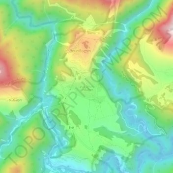
Name: Omalo topographic map, elevation, terrain.
Location: Omalo, Akhmeta Municipality, Kakheti, Georgia (42.35092 45.61308 42.39092 45.65308)
Average elevation: 1,871 m
Minimum elevation: 1,610 m
Maximum elevation: 2,359 m
Thank you for supporting this site ❤️
Make a donation
Make a donation
Other topographic maps
Click on a map to view its topography, its elevation and its terrain.