
Tsitsamura topographic map
Click on the map to display elevation.
About this map
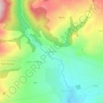
Name: Tsitsamura topographic map, elevation, terrain.
Location: Tsitsamura, Dusheti Municipality, Mtskheta-Mtianeti, Georgia (42.01347 44.57022 42.05347 44.61022)
Average elevation: 834 m
Minimum elevation: 697 m
Maximum elevation: 1,044 m
Other topographic maps
Click on a map to view its topography, its elevation and its terrain.
Dusheti
Georgia > Mtskheta-Mtianeti > Dusheti Municipality
Dusheti is on both banks of the small, mountainous Dushetis-Khevi River in the foothills of the Greater Caucasus range at an elevation of 900 m. The town is 33 km north of Mtskheta and 54 km northeast from the capital Tbilisi. Dusheti has a moderately humid climate, with moderately cold winters and long warm…
Average elevation: 892 m
Pasanauri
Georgia > Mtskheta-Mtianeti > Dusheti Municipality
Pasanauri lies about 90 kilometres (56 mi) north of the nation's capital of Tbilisi, at elevation of 1,050 m. above sea level. Located on the Georgian Military Road, Pasanauri is flanked by the Aragvi River, and surrounded by the Caucasus Mountains. Average winter temperature is 0 degrees Celsius, but often…
Average elevation: 1,507 m