
Make a donation
Very steep, dangerous route topographic map
Click on the map to display elevation.
Make a donation
About this map
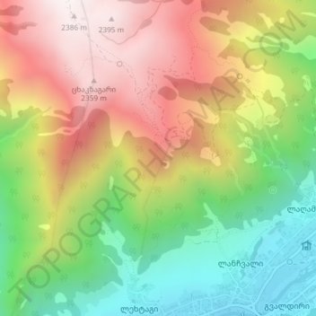
Name: Very steep, dangerous route topographic map, elevation, terrain.
Average elevation: 1,875 m
Minimum elevation: 1,389 m
Maximum elevation: 2,402 m
Make a donation
Other topographic maps
Click on a map to view its topography, its elevation and its terrain.
Mestia
Georgia > Samegrelo-Upper Svaneti > Mestia Municipality
Mestia (Georgian: მესტია IPA: [mestʼia]) is a highland townlet (daba) in northwest Georgia, at an elevation of 1,500 metres (4,921 feet) in the Caucasus Mountains.
Average elevation: 1,761 m
Make a donation
Mestia
Georgia > Samegrelo-Upper Svaneti > Mestia Municipality
Mestia (Georgian: მესტია IPA: [mestʼia]) is a highland townlet (daba) in northwest Georgia, at an elevation of 1,500 metres (4,921 feet) in the Caucasus Mountains.
Average elevation: 1,761 m
Make a donation
Mestia
Georgia > Samegrelo-Upper Svaneti > Mestia Municipality
Mestia (Georgian: მესტია IPA: [mestʼia]) is a highland townlet (daba) in northwest Georgia, at an elevation of 1,500 metres (4,921 feet) in the Caucasus Mountains.
Average elevation: 1,761 m