
Thank you for supporting this site ❤️
Make a donation
Make a donation
Manglisi topographic map
Click on the map to display elevation.
Thank you for supporting this site ❤️
Make a donation
Make a donation
About this map
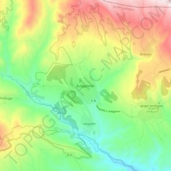
Name: Manglisi topographic map, elevation, terrain.
Location: Manglisi, Tetritskaro Municipality, Lower Kartli, Georgia (41.65866 44.34307 41.73866 44.42307)
Average elevation: 1,311 m
Minimum elevation: 955 m
Maximum elevation: 1,843 m
Thank you for supporting this site ❤️
Make a donation
Make a donation
Other topographic maps
Click on a map to view its topography, its elevation and its terrain.
Tetritskaro
Georgia > Lower Kartli > Tetritskaro Municipality > Tetritskaro
Average elevation: 1,162 m
Thank you for supporting this site ❤️
Make a donation
Make a donation