
Ceredigion topographic map
Interactive map
Click on the map to display elevation.
About this map
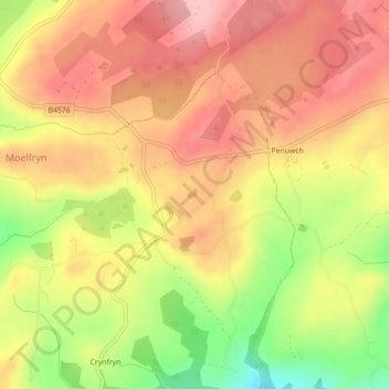
Name: Ceredigion topographic map, elevation, terrain.
Location: Ceredigion, Gales, Reino Unido (52.24267 -4.06724 52.24279 -4.06704)
Average elevation: 282 m
Minimum elevation: 187 m
Maximum elevation: 343 m
Other topographic maps
Click on a map to view its topography, its elevation and its terrain.
Burwen
Reino Unido > Gales > Ynys Môn / Isle of Anglesey
Burwen, Ynys Môn / Isle of Anglesey, Gales, LL68 9TA, Reino Unido
Average elevation: 33 m
Magor
Reino Unido > Gales > Monmouthshire
Magor, Monmouthshire, Gales, NP26 3EG, Reino Unido
Average elevation: 20 m
Chapel Hill
Reino Unido > Gales > Monmouthshire > Tintern
Chapel Hill, Tintern, Monmouthshire, Gales, NP16 6TJ, Reino Unido
Average elevation: 137 m
Castell Trefaldwyn
Reino Unido > Gales > Powys > Montgomery
Castell Trefaldwyn, Rhodfa'r Castell, Montgomery, Powys, Gales, SY15 6ES, Reino Unido
Average elevation: 158 m
Saron
Reino Unido > Gales > Carmarthenshire
Saron, Llangeler, Carmarthenshire, Gales, Reino Unido
Average elevation: 139 m
Glascoed
Reino Unido > Gales > Monmouthshire > Glascoed
Glascoed, Monmouthshire, Gales, NP4 0TZ, Reino Unido
Average elevation: 86 m
Y Bontnewydd
Reino Unido > Gales > Y Bontnewydd
Y Bontnewydd, Gwynedd, Gales, LL54 7UR, Reino Unido
Average elevation: 58 m