
Magor topographic map
Interactive map
Click on the map to display elevation.
About this map
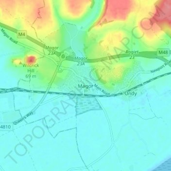
Name: Magor topographic map, elevation, terrain.
Location: Magor, Monmouthshire, Gales, NP26 3EG, Reino Unido (51.56012 -2.85076 51.60012 -2.81076)
Average elevation: 20 m
Minimum elevation: 0 m
Maximum elevation: 79 m
Other topographic maps
Click on a map to view its topography, its elevation and its terrain.
Chapel Hill
Reino Unido > Gales > Monmouthshire > Tintern
Chapel Hill, Tintern, Monmouthshire, Gales, NP16 6TJ, Reino Unido
Average elevation: 137 m
Glascoed
Reino Unido > Gales > Monmouthshire > Glascoed
Glascoed, Monmouthshire, Gales, NP4 0TZ, Reino Unido
Average elevation: 86 m