Geolocate

Cebu topographic map

Interactive map

Click on the map to display elevation.

Cebu

Coal was first discovered in Cebu about 1837. There were 15 localities over the whole island, on both coasts; some desultory mining had been carried out Naga near Mount Uling, but most serious operations were at Licos and Camansi west of Compostela and Danao. Active work ceased about 1895 with insurrections, and no production worked for more than ten years. A topographic and geologic survey of Compostela, Danao, and Carmen took place in 1906. The Compostela-Danao coalfield contained about six million workable tons. The tramroads, one from Danao to Camansi, one from Compostela to Mount Licos, were undertaken in 1895, together with a wagon road built in 1877, from Cotcot to Dapdap.

Wikipedia (CC-BY-SA 3.0)

About this map

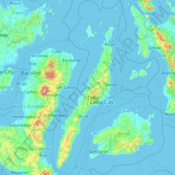
Name: Cebu topographic map, elevation, terrain.

Location: Cebu, Central Visayas, Philippines (9.32785 123.23527 11.62616 124.66718)

Average elevation: 91 m

Minimum elevation: -2 m

Maximum elevation: 2,362 m

Other topographic maps

Click on a map to view its topography, its elevation and its terrain.

Cebu City

Philippines > Cebu > Cebu City

Average elevation: 140 m

Alfonso

Philippines > Cavite > Alfonso

Average elevation: 413 m

Ilawod

Philippines > Camarines Sur > Caramoan

Average elevation: 64 m

Quezon City

Philippines

Founded as a pueblo by Saint Pedro Bautista in 1590, San Francisco del Monte may be considered Quezon City's oldest district. The original land area of the old town of San Francisco del Monte was approximately2.5 square kilometres (1.0 sq mi) and covered parts of what is currently known as Project 7 and 8 and…

Average elevation: 57 m

Caloocan

Philippines > Caloocan > Caloocan

Average elevation: 19 m

Kuya

Philippines > Bukidnon > Maramag

Average elevation: 682 m

Naga

Philippines > Cebu

Average elevation: 102 m

Malumpati Cold Spring

Philippines > Antique > Pandan > Buang > Santa Cruz

Average elevation: 72 m

Cuayang Bugtong

Philippines > Pampanga > Candaba

Average elevation: 11 m

San Jose de Buan

Philippines > Samar

Average elevation: 299 m

Aberawan

Philippines > Palawan > El Nido

Average elevation: 37 m

San Martin

Philippines > Bukidnon > Malaybalay

Average elevation: 386 m

Mainit

Philippines > Leyte > Alangalang > Binungto-an

Average elevation: 40 m

Mandaluyong

Philippines

Another claims that the Spaniards named the place based on the report of a navigator named Acapulco, who saw the rolling hills frequently being lashed at by daluyong (“big waves from the sea”). This seems to confirm traditional pre-Hispanic stories that giant waves from the sea would meet the adjoining…

Average elevation: 33 m

Bacolod

Philippines

Bacólod (English: Bacolod), is derived from bakólod (Old Spelling: bacólod), the Old Hiligaynon (Old Ilonggo) (Old Spelling: Ylongo and Ilongo) word for a "hill, turtle, mound, rise, hillock, down, any small eminence or elevation", since the resettlement was founded on a stony, hilly area, now the barangay…

Average elevation: 49 m

Santa Rosa

Philippines > Laguna > Santa Rosa

Average elevation: 65 m

Tunasan River

Philippines > Muntinlupa

Average elevation: 47 m

Embarcadero

Philippines > Pangasinan > Mangaldan

Average elevation: 7 m

Dalicanan

Philippines > Iloilo

Average elevation: 131 m

Bagong Silang

Philippines > Isabela > Ilagan

Average elevation: 56 m

Maislap

Philippines > Rizal > Montalban

Average elevation: 82 m

Lumondao

Philippines > Davao City

Average elevation: 488 m

Energy Park

Philippines > Davao del Norte > Tagum

Average elevation: 18 m

Patong-patong

Philippines > Iloilo

Average elevation: 106 m

Dugmanon

Philippines > Davao Oriental > San Isidro

Average elevation: 127 m

Bagabag

Philippines > Nueva Vizcaya

Average elevation: 262 m

Gatbuca

Philippines > Bulacan > Calumpit

Average elevation: 5 m

Zamboanga City

Philippines > Zamboanga Peninsula > Zamboanga City

The overall topography of the city could be described as rolling to very steep. There are some flat lands, mostly narrow strips along the east coast. The urban center is mostly flat with a gentle slope to the interior, ranging from 0 to 3%. The highest registered elevation is 1,200 metres. In terms of slope, a…

Average elevation: 83 m

Tagaytay

Philippines > Cavite

The southern and eastern portions of Tagaytay are covered by hills and mountains which is generally forests, pine trees and open grasslands. The city lies along Tagaytay Ridge, a ridge stretching about 32 kilometres (20 mi) from Mount Batulao in the west to Mount Sungay in the east with elevations averaging…

Average elevation: 229 m

Amadeo

Philippines > Cavite > Amadeo

Average elevation: 422 m

Tanay

Philippines > Rizal

Average elevation: 32 m

Bacoor

Philippines > Cavite

Average elevation: 18 m

Tamacan

Philippines > Cavite > Amadeo

Average elevation: 293 m

Nauring

Philippines > Antique > Pandan

Average elevation: 12 m

Townsite

Philippines > Bataan > Limay

Average elevation: 20 m

Camarag

Philippines > Isabela

Average elevation: 72 m

Ramirez

Philippines > Cavite > Magallanes

Average elevation: 190 m

Malainen Luma

Philippines > Cavite > Naic

Average elevation: 54 m

Monte Claro

Philippines > Occidental Mindoro > San Jose

Average elevation: 86 m

San Roque

Philippines > Bulacan > Pandi

Average elevation: 26 m

Tatawiran

Philippines > Quezon > General Nakar

Average elevation: 617 m

Raradangan

Philippines > North Cotabato > Alamada

Average elevation: 234 m

Carmen

Philippines > Cebu

Average elevation: 59 m

San Narciso

Philippines > Zambales

San Narciso is located in a relatively flat plain. West of the town is the South China Sea and to the east is bordered by the Sto. Tomas river are the Zambales Mountain Ranges. Average elevation is 3.6 metres (12 ft) above sea level and the highest elevation is 800 metres (2,600 ft) above sea level.

Average elevation: 11 m

Buenavista

Philippines > Quezon

Average elevation: 66 m

San Fernando

Philippines > Pampanga

Average elevation: 24 m

Purok 3

Philippines > Samar > Santa Margarita > Burabod

Average elevation: 13 m

Punta Tabuc

Philippines > Capiz > Roxas

Average elevation: 5 m

San Antonio

Philippines > Albay > Tabaco

Average elevation: 73 m

Cainta

Philippines > Rizal

Average elevation: 24 m

Nagas

Philippines > Albay

Average elevation: 32 m

Luciano

Philippines > Cavite > Trece Martires

Average elevation: 126 m

Butig

Philippines > Lanao del Sur

Average elevation: 806 m

Tierra Nevada

Philippines > Camarines Sur

Average elevation: 153 m

Masinloc

Philippines > Zambales

Average elevation: 13 m

Antipolo

Philippines > Rizal

Its higher elevation than that of Metro Manila affords it a scenic view of the metropolis, especially at night. Its locally grown mangoes and cashews are popular among tourists, as well as suman – a local delicacy made out of glutinous rice. The Hinulugang Taktak National Park, which was once a popular…

Average elevation: 125 m

Iligan

Philippines

Average elevation: 229 m

Dan-ar

Philippines > Ilocos Sur

Average elevation: 52 m

Tibolo

Philippines > Davao del Sur > Santa Cruz

Average elevation: 991 m

Amsipit

Philippines > Sarangani > Maasim

Average elevation: 499 m

Crossing Diamond

Philippines > Davao City > Datu Salumay

Average elevation: 1,114 m

Dalwangan

Philippines > Bukidnon > Malaybalay

Average elevation: 892 m

Tagoloan

Philippines > Misamis Oriental

Average elevation: 22 m

Ligaya

Philippines > Occidental Mindoro > Sablayan

Average elevation: 699 m

Kaylaway

Philippines > Batangas > Nasugbu

Average elevation: 431 m

Splash Island

Philippines > Laguna > Biñan

Average elevation: 21 m

San Juan

Philippines > Tarlac > Capas

Average elevation: 48 m

Upper Libungan

Philippines > Davao City > Calinan > Lamanan

Average elevation: 273 m

Bentung

Philippines > South Cotabato > Polomolok

Average elevation: 335 m

Bantay

Philippines > Ilocos Sur

It has an average elevation of 100 meters (328.08 feet), with a land area of 7,660 hectares (18,900 acres). It is an elevated and hilly municipality but some barangays, especially those near creeks, are prone to flooding during heavy typhoons.

Average elevation: 8 m

Montalban

Philippines > Rizal > Rodriguez

Rodriguez is generally very rough in topography, with 83% of its total land area composed of upland areas, hills and mountain ranges. The remaining 17% low-lying terrain and rolling lands are found at the south-western portion of the municipality, along with the northern portions of the Municipality of San…

Average elevation: 99 m

Little Ville

Philippines > Rizal > Tanay

Average elevation: 55 m

Mount Malabito

Philippines > Quezon > General Nakar

Average elevation: 963 m

Pagsangahan

Philippines > Catanduanes > San Miguel

Average elevation: 171 m

Maslog

Philippines > Eastern Samar

Average elevation: 57 m

Butuan

Philippines

Average elevation: 115 m

San Juan

Philippines

"San Juan" is a contraction of the city's traditional name of "San Juan del Monte" (lit. 'Saint John of the Mountain'). As with numerous other places in the Philippines, the name combines a patron saint and a toponym; in this case Saint John the Baptist with the locale's hilly terrain and relatively higher…

Average elevation: 35 m

Manaoag

Philippines > Isabela

Average elevation: 46 m

Samal Island

Philippines > Davao del Norte > Samal

Average elevation: 117 m

Mount Natib

Philippines > Bataan > Morong

Mount Natib is a stratovolcano type of volcano topped by a 6-by-7-kilometre (3.7 by 4.3 mi) acorn-shaped Natib Caldera that is open to the northwest. East of its caldera is the smaller 2-kilometre (1.2 mi) wide Pasukulan Caldera. The highest peak of Mount Natib has an elevation of 1,253 metres (4,111 ft) asl…

Average elevation: 846 m

Jolo

Philippines > Sulu

Average elevation: 57 m

Suyo

Philippines > Ilocos Sur

Average elevation: 259 m

Tiguib

Philippines > Cebu > Badian

Average elevation: 316 m

Tiep

Philippines > Pangasinan

Average elevation: 100 m

Sacol

Philippines > Agusan del Norte > Buenavista

Average elevation: 3 m

Canipa

Philippines > Davao de Oro > Pantukan

Average elevation: 10 m

Mayuro

Philippines > Batangas > Rosario

Average elevation: 142 m

Talim Island

Philippines > Rizal > Kinaboogan

Average elevation: 13 m

Mataas na Burol

Philippines > Cavite > Silang

Average elevation: 447 m

Banaba Lejos

Philippines > Cavite > Indang

Average elevation: 152 m

Santo Domingo

Philippines > Isabela

Average elevation: 46 m

Pan-ngat

Philippines > Ifugao > Banaue > Tam-an

Average elevation: 1,224 m

Balindog

Philippines > North Cotabato > Kidapawan

Average elevation: 179 m

Veterans

Philippines > South Cotabato

Average elevation: 332 m

Sorsogon City

Philippines > Sorsogon

Sorsogon City covers a land area of 31,292 hectares (120.82 sq mi). It is at the southernmost tip of the Bicol Peninsula and of Luzon Island. The city is bounded by Castilla in the west, Manito in the northwest, Albay Gulf in the north, Prieto Diaz in the east, Gubat in the southeast, Casiguran in the…

Average elevation: 89 m

Pasay

Philippines

Average elevation: 14 m