Geolocate

Negros Occidental topographic map

Interactive map

Click on the map to display elevation.

Negros Occidental

Negros Occidental has a tropical climate due to the fact that it is situated close to the equator, being located at least nine degrees north of it. The northern section of the province has a tropical rainforest (Köppen: Af) climate, whereas the southern portion has a tropical monsoon (Köppen: Am) climate. Mount Kanlaon itself, along with its higher-elevated slopes, are classified as having a dry-winter subtropical highland climate (Köppen: Cwb) due to their higher elevations, allowing for a significantly cooler temperature compared to the province as a whole.

Wikipedia (CC-BY-SA 3.0)

About this map

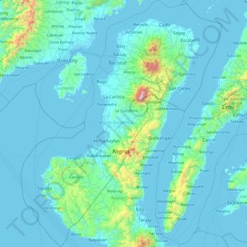
Name: Negros Occidental topographic map, elevation, terrain.

Location: Negros Occidental, Negros Island Region, Philippines (9.31082 122.22618 11.13784 123.73485)

Average elevation: 125 m

Minimum elevation: -2 m

Maximum elevation: 2,356 m

Other topographic maps

Click on a map to view its topography, its elevation and its terrain.

Quezon City

Philippines

Founded as a pueblo by Saint Pedro Bautista in 1590, San Francisco del Monte may be considered Quezon City's oldest district. The original land area of the old town of San Francisco del Monte was approximately2.5 square kilometres (1.0 sq mi) and covered parts of what is currently known as Project 7 and 8 and…

Average elevation: 57 m

Santa Rosa

Philippines > Laguna > Santa Rosa

Average elevation: 65 m

Linapew

Philippines > La Union > Pugo

Average elevation: 138 m

M.V. Hechanova

Philippines > Iloilo > Leganes

Average elevation: 3 m

Tacunan

Philippines > Davao City

Average elevation: 138 m

Cebu City

Philippines > Cebu > Cebu City

Average elevation: 140 m

Sonlon

Philippines > Davao del Norte

Average elevation: 77 m

Ditawini

Philippines > Aurora

Average elevation: 80 m

Solano

Philippines > Nueva Vizcaya

Average elevation: 262 m

Ceboza

Philippines > Davao del Sur > Matanao

Average elevation: 50 m

Guisguis-San Roque

Philippines > Quezon > Sariaya

Average elevation: 8 m

General Lim

Philippines > Bataan > Orion

Average elevation: 43 m

San Fernando

Philippines > Pampanga

Average elevation: 24 m

Antipolo

Philippines > Rizal

Its higher elevation than that of Metro Manila affords it a scenic view of the metropolis, especially at night. Its locally grown mangoes and cashews are popular among tourists, as well as suman – a local delicacy made out of glutinous rice. The Hinulugang Taktak National Park, which was once a popular…

Average elevation: 125 m

Bangga Pototan

Philippines > Iloilo > Patag

Average elevation: 16 m

Mandaluyong

Philippines

Another claims that the Spaniards named the place based on the report of a navigator named Acapulco, who saw the rolling hills frequently being lashed at by daluyong (“big waves from the sea”). This seems to confirm traditional pre-Hispanic stories that giant waves from the sea would meet the adjoining…

Average elevation: 33 m

Amadeo

Philippines > Cavite > Amadeo

Average elevation: 422 m

Tanay

Philippines > Rizal

Average elevation: 32 m

Tacloban

Philippines > Leyte > Tacloban

Average elevation: 29 m

Samal Island

Philippines > Davao del Norte > Samal

Average elevation: 117 m

Malabobo

Philippines > Pangasinan > Mangatarem

Average elevation: 116 m

Brgy. San Roque

Philippines > Southern Leyte

Average elevation: 127 m

Manggalang Kiling

Philippines > Quezon > Sariaya

Average elevation: 8 m

Tanggoy

Philippines > Batangas > Balayan

Average elevation: 53 m

Tumiao

Philippines > Sultan Kudarat

Average elevation: 27 m

Bacolod

Philippines

Bacólod (English: Bacolod), is derived from bakólod (Old Spelling: bacólod), the Old Hiligaynon (Old Ilonggo) (Old Spelling: Ylongo and Ilongo) word for a "hill, turtle, mound, rise, hillock, down, any small eminence or elevation", since the resettlement was founded on a stony, hilly area, now the barangay…

Average elevation: 49 m

Pasay

Philippines

Average elevation: 14 m

Daraga

Philippines > Albay

67.3% of the total municipal land area has a predominantly low elevation of up to 100 metres (330 ft). The surface terrain is generally characterized by combination of level to nearly level areas, gentle to undulating areas and undulating to rolling areas.

Average elevation: 76 m

San Pablo

Philippines > Laguna > San Pablo

Average elevation: 220 m

Talim Island

Philippines > Rizal > Kinaboogan

Average elevation: 13 m

Baco

Philippines > Oriental Mindoro

Majority of the barangays of the municipality are in lowland areas or below 500 meters above sea level (MASL) and cover 41.88 percent of the total land area (13,035.58 ha). The three largest barangays, which cover most of the forestland, have an elevation that ranges from 500-1,000 and greater than 1,000…

Average elevation: 14 m

San Jose

Philippines > Pangasinan > Labrador

Average elevation: 42 m

Visita

Philippines > Albay > Tabaco

Average elevation: 9 m

Hamlet

Philippines > Bataan > Bagac

Average elevation: 56 m

Atok

Philippines > Benguet

Average elevation: 1,814 m

Mount Bulusan

Philippines > Sorsogon

Average elevation: 1,036 m

Sinampongan

Philippines > Misamis Occidental

Average elevation: 477 m

Catigbi-an

Philippines > Bohol

Average elevation: 216 m

Agus-os

Philippines > Cavite > Indang

Average elevation: 201 m

Carmencita

Philippines > Isabela > Delfin Albano

Average elevation: 58 m

Mawab

Philippines > Davao de Oro

Average elevation: 116 m

Butuan

Philippines

Average elevation: 115 m

Malolos

Philippines > Bulacan

Malolos is relatively flat of about 0.81% to a gently sloping of 2.17%. The slope of the land descends towards west, southwest to southern direction. The highest land elevation is at about 6.0 meters above sea level while the lowest is only half a meter below sea level. A network of natural waterways and…

Average elevation: 6 m

Cabanatuan

Philippines > Nueva Ecija

Average elevation: 47 m

Montalban

Philippines > Rizal > Rodriguez

Rodriguez is generally very rough in topography, with 83% of its total land area composed of upland areas, hills and mountain ranges. The remaining 17% low-lying terrain and rolling lands are found at the south-western portion of the municipality, along with the northern portions of the Municipality of San…

Average elevation: 99 m

Indang

Philippines > Cavite > Indang

The topography of Indang is characterised by gently sloping or rolling terrain. Almost 40.36% of its total land area is within the slope grade of 3-8%, while 2,135 hectares is within the slope range of 8-15% which is characterised by undulating or sloping terrain.

Average elevation: 298 m

Mandaue

Philippines

It is one of the two (the other one being the municipality of Consolacion) local government units located within the mainland Metro Cebu where the elevation of land is less than 100 m (330 ft).

Average elevation: 109 m

Alfonso

Philippines > Cavite > Alfonso

Average elevation: 413 m

Paligui

Philippines > Pampanga > Apalit

Average elevation: 3 m

Baguio

Philippines > Quezon > Tayabas

Average elevation: 191 m

Saay

Philippines > Cebu > Carcar

Average elevation: 114 m

Cutcutan

Philippines > Bohol

Average elevation: 35 m

Dawis Sur

Philippines > Cebu > Carmen

Average elevation: 20 m

Dipolog

Philippines > Zamboanga del Norte

Average elevation: 40 m

Iba O'Este

Philippines > Bulacan > Calumpit

Average elevation: 4 m

Claver

Philippines > Surigao Del Norte

Average elevation: 28 m

Jalaud Norte

Philippines > Iloilo > Zarraga

Average elevation: 9 m

Valencia

Philippines > Bohol

Average elevation: 57 m

San Agustin Norte

Philippines > Pampanga > Arayat

Average elevation: 13 m

Bindoy

Philippines > Negros Oriental

Average elevation: 128 m

San Lorenzo

Philippines > Agusan del Sur > Prosperidad

Average elevation: 127 m

Bato

Philippines > Capiz > Cuartero > Bitoon Ilaya

Average elevation: 24 m

Aplaya

Philippines > Aurora > Dingalan

Average elevation: 80 m

Sulucan

Philippines > Bulacan > Angat

Average elevation: 34 m

Castañas

Philippines > Quezon > Sariaya

Average elevation: 9 m

Catlubong

Philippines > Benguet

Average elevation: 1,869 m

Paligui

Philippines > Pampanga > Candaba

Average elevation: 9 m

Baclayon

Philippines > Bohol

Average elevation: 41 m

Poblacion 1

Philippines > Palawan > Coron

Average elevation: 33 m

Santa Fe

Philippines > Antique > Pandan

Average elevation: 20 m

Tadian

Philippines > Mountain Province

Average elevation: 1,155 m

Pagal

Philippines > Benguet > La Trinidad > Beckel

Average elevation: 1,403 m

Mankayan

Philippines > Benguet

Average elevation: 1,315 m

Aggub

Philippines > Isabela

Average elevation: 35 m

Badian Island

Philippines > Samar > Daram > Mandoyucan

Average elevation: 13 m

Zamboanga City

Philippines > Zamboanga Peninsula > Zamboanga City

The overall topography of the city could be described as rolling to very steep. There are some flat lands, mostly narrow strips along the east coast. The urban center is mostly flat with a gentle slope to the interior, ranging from 0 to 3%. The highest registered elevation is 1,200 metres. In terms of slope, a…

Average elevation: 83 m

San Fernando

Philippines > La Union

Average elevation: 81 m

Villarica

Philippines > North Cotabato

Average elevation: 27 m

Arcon

Philippines > Isabela

Average elevation: 41 m

Gugo

Philippines > Bulacan > Calumpit

Average elevation: 4 m

Paligui

Philippines > Pampanga > Candaba

Average elevation: 9 m

Igcocolo

Philippines > Iloilo > Guimbal

Average elevation: 53 m

Butong

Philippines > Bukidnon > Quezon

Average elevation: 383 m

Guagua River

Philippines > Pampanga > Sasmuan > San Pedro

Average elevation: 2 m

Banquerohan

Philippines > Negros Occidental > Cadiz

Average elevation: 7 m

Dahilayan

Philippines > Bukidnon > Manolo Fortich

Average elevation: 1,116 m

San Rafael

Philippines > Sorsogon > Pilar

Average elevation: 8 m

Am-iyong

Philippines > Ifugao > Hungduan

Average elevation: 1,000 m

Pagadian

Philippines > Zamboanga del Sur

Average elevation: 169 m

Sorsogon City

Philippines > Sorsogon

Sorsogon City covers a land area of 31,292 hectares (120.82 sq mi). It is at the southernmost tip of the Bicol Peninsula and of Luzon Island. The city is bounded by Castilla in the west, Manito in the northwest, Albay Gulf in the north, Prieto Diaz in the east, Gubat in the southeast, Casiguran in the…

Average elevation: 89 m

Urdaneta

Philippines > Pangasinan

Average elevation: 42 m

Catlubong

Philippines > Benguet

Average elevation: 1,869 m

Pandan

Philippines > Romblon > Santa Fe

Average elevation: 38 m

Lubuagan

Philippines > Kalinga

Average elevation: 809 m