
Huila topographic map
Interactive map
Click on the map to display elevation.
About this map
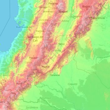
Name: Huila topographic map, elevation, terrain.
Location: Huila, Colombia (-0.12610 -78.19001 5.07390 -72.99001)
Average elevation: 954 m
Minimum elevation: -2 m
Maximum elevation: 5,469 m
Other topographic maps
Click on a map to view its topography, its elevation and its terrain.
Bogota Capital District - Municipality
The city is located in the center of Colombia, on a high plateau known as the Bogotá savanna, part of the Altiplano Cundiboyacense located in the Eastern Cordillera of the Andes. Its altitude averages 2,640 meters (8,660 ft) above sea level. Subdivided into 20 localities, Bogotá has an area of 1,587 square…
Average elevation: 2,183 m
Boyacá
The department of Boyacá covers a small portion of the Middle Magdalena valley of the Magdalena River to the west, the Cordillera Oriental mountain range with altitudes of 5,380 m above sea level (Sierra Nevada del Cocuy with 25 snow peaks), flat highland plateaux, and another small portion of territory by…
Average elevation: 1,402 m
Bogota, Capital District
Bogotá is located in the southeastern part of the Bogotá savanna (Sabana de Bogotá) at an average altitude of 2,640 meters (8,660 ft) above sea level. The Bogotá savanna is popularly called "savannah" (sabana), but constitutes actually a high plateau in the Andes mountains, part of an extended region known…
Average elevation: 2,183 m
Ibagué
Ibagué features a tropical rainforest climate under the Köppen climate classification, albeit a relatively cooler version of the climate due to the high altitude. Although the city does experience noticeably drier conditions during and around the months of January and July, the city has no true dry season…
Average elevation: 1,907 m
Bucaramanga
Colombia > Santander > Bucaramanga
Bucaramanga is located on a plateau in the Cordillera Oriental of the Colombian Andes, and many residents occupy unstable lands descending steeply from the meseta. Westbound of it, the Rio de Oro Canyon is located at an altitude of 600 metres (2,000 ft) above sea level. Eastbound, the Andean Range rises up in…
Average elevation: 1,001 m
Magdalena
The Department of Magdalena, because of its terrain, and proximity to the sea has an unstable weather. Its Climate is mainly dictated by its global positioning, and because the department of Magdalena is located on the Intertropical Convergence Zone it possess an inter-tropical climate. Temperature in the…
Average elevation: 407 m
Antioquia
Due to its geographical isolation (as it is located among mountains), Antioquia suffered supply problems. Its topography did not allow for much agriculture, so the city became dependent upon trade, especially of gold and gin for the colonization of new land. Much of this trade was due to reforms passed after a…
Average elevation: 608 m