
Ibagué topographic map
Interactive map
Click on the map to display elevation.
About this map
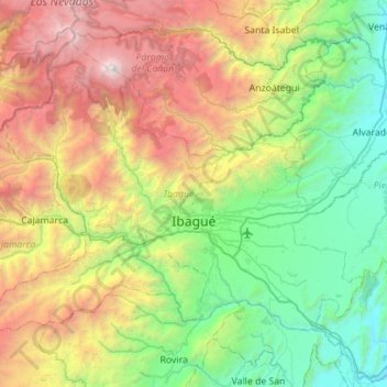
Name: Ibagué topographic map, elevation, terrain.
Location: Ibagué, Centro, Tolima, RAP (Especial) Central, Colombia (4.25786 -75.52470 4.69933 -74.96675)
Average elevation: 1,907 m
Minimum elevation: 308 m
Maximum elevation: 5,213 m
Ibagué features a tropical rainforest climate under the Köppen climate classification, albeit a relatively cooler version of the climate due to the high altitude. Although the city does experience noticeably drier conditions during and around the months of January and July, the city has no true dry season month, as all twelve months see on average more than 60 mm (2.4 in) of rain. As is commonplace in areas with this climate, temperatures are relatively consistent throughout the course of the year in Ibagué, with average high temperatures of about 28 °C or 82.4 °F and average low temperatures of about 18 °C or 64.4 °F. On average Ibagué sees 1,700 mm (66.9 in) of rain annually.
Other topographic maps
Click on a map to view its topography, its elevation and its terrain.
Cordillera Central
Cordillera Central, Planadas, Sur, Tolima, Colombia
Average elevation: 3,706 m
Vega Larga
Colombia > Tolima > Vega Larga
Vega Larga, Ataco, Tolima, Colombia
Average elevation: 1,493 m