
Thank you for supporting this site ❤️
Make a donation
Make a donation
Duitama topographic map
Click on the map to display elevation.
Thank you for supporting this site ❤️
Make a donation
Make a donation
About this map
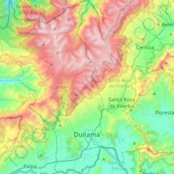
Name: Duitama topographic map, elevation, terrain.
Location: Duitama, Tundama, Boyacá, RAP (Especial) Central, Colombia (5.77007 -73.17625 6.02490 -72.99248)
Average elevation: 3,019 m
Minimum elevation: 2,374 m
Maximum elevation: 4,036 m
Thank you for supporting this site ❤️
Make a donation
Make a donation
Other topographic maps
Click on a map to view its topography, its elevation and its terrain.