
Boyacá topographic map
Click on the map to display elevation.
Boyacá
The department of Boyacá covers a small portion of the Middle Magdalena valley of the Magdalena River to the west, the Cordillera Oriental mountain range with altitudes of 5,380 m above sea level (Sierra Nevada del Cocuy with 25 snow peaks), flat highland plateaux, and another small portion of territory by the eastern Llanos plains. Among its most prominent geographical features are the Range of the Zorro, Serrania de las Quinchas and the Andean plateaus of Rusia, Guantivá, Pisba, Chontales and Rechiniga.
About this map
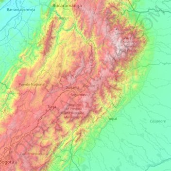
Name: Boyacá topographic map, elevation, terrain.
Location: Boyacá, RAP (Especial) Central, Colombia (4.65581 -74.65933 7.05484 -71.94333)
Average elevation: 1,402 m
Minimum elevation: 62 m
Maximum elevation: 5,125 m
Other topographic maps
Click on a map to view its topography, its elevation and its terrain.
Centro
Colombia > Norte de Santander > Villa del Rosario > Villa del Rosario > Centro
Average elevation: 433 m