
Provincia de Huamanga topographic map
Interactive map
Click on the map to display elevation.
About this map
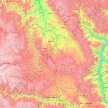
Name: Provincia de Huamanga topographic map, elevation, terrain.
Location: Provincia de Huamanga, Ayacucho, Perú (-13.53848 -74.68607 -12.98037 -73.82718)
Average elevation: 3,581 m
Minimum elevation: 1,717 m
Maximum elevation: 5,121 m
Other topographic maps
Click on a map to view its topography, its elevation and its terrain.
Coronel Castañeda
Coronel Castañeda, Parinacochas, Ayacucho, Perú
Average elevation: 4,426 m
Las Tapias
Perú > Ayacucho > Las Tapias
Las Tapias, Parinacochas, Ayacucho, Perú
Average elevation: 3,373 m