
Thank you for supporting this site ❤️
Make a donation
Make a donation
Coronel Castañeda topographic map
Click on the map to display elevation.
Thank you for supporting this site ❤️
Make a donation
Make a donation
About this map
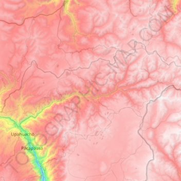
Name: Coronel Castañeda topographic map, elevation, terrain.
Location: Coronel Castañeda, Parinacochas, Ayacucho, Perú (-14.92349 -73.41961 -14.62308 -72.84682)
Average elevation: 4,426 m
Minimum elevation: 2,666 m
Maximum elevation: 5,092 m
Thank you for supporting this site ❤️
Make a donation
Make a donation
Other topographic maps
Click on a map to view its topography, its elevation and its terrain.
Thank you for supporting this site ❤️
Make a donation
Make a donation