
Make a donation
Tana Tidung topographic map
Click on the map to display elevation.
Make a donation
Tana Tidung
The Tana Tidung Regency has a land area of 4,058.70 kilometres (2,521.96 mi). It borders the Nunukan Regency in the north, the Celebes Sea and the city of Tarakan in the east, the Malinau Regency in the west, and the Bulungan Regency in the south. The region's topography varies between 0–40% grade. However, most of it is considered a high-altitude region with steep slopes; most of its flat land with a slope of less than 8% is along the coast. The regency's soil composition is dominated by ultisol and inceptisol and is generally unsuitable for large-scale agriculture.
Make a donation
About this map
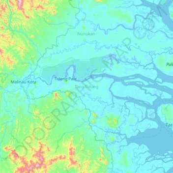
Name: Tana Tidung topographic map, elevation, terrain.
Location: Tana Tidung, North Kalimantan, Kalimantan, 77152, Indonesia (3.31384 116.67134 3.79626 117.82596)
Average elevation: 83 m
Minimum elevation: -8 m
Maximum elevation: 1,115 m
Make a donation
Other topographic maps
Click on a map to view its topography, its elevation and its terrain.
Make a donation
Make a donation
Make a donation
Make a donation
Make a donation
Make a donation
Make a donation
Make a donation
Make a donation
Make a donation
Make a donation
Make a donation
Make a donation