
Sarawak topographic map
Interactive map
Click on the map to display elevation.
About this map
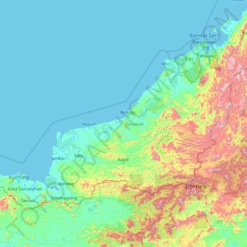
Name: Sarawak topographic map, elevation, terrain.
Location: Sarawak, Malaysia (0.85382 109.53804 5.10833 115.67803)
Average elevation: 228 m
Minimum elevation: -4 m
Maximum elevation: 2,148 m
Sarawak can be divided into two geological zones: the Sunda Shield, which extends southwest from the Batang Lupar River (near Sri Aman) and forms the southern tip of Sarawak, and the geosyncline region, which extends northeast to the Batang Lupar River, forming the central and northern regions of Sarawak. The oldest rock type in southern Sarawak is schist formed during the Carboniferous and Lower Permian times, while the youngest igneous rock in this region, andesite, can be found at Sematan. Geological formation of the central and northern regions started during the late Cretaceous period. Other types of stone that can be found in central and northern Sarawak are shale, sandstone, and chert. The Miri Division in eastern Sarawak is the region of Neogene strata containing organic rich rock formations which are the prolific oil and gas reserves. The rocks enriched in organic components are mudstones in Lambir, Miri and Tukau Formations of Middle Miocene-Lower Pliocene age. Significant quantities of Sarawak soil are lithosols, up to 60 per cent, and podsols, around 12 per cent, while abundant alluvial soil is found in coastal and riverine regions. 12 per cent of Sarawak is covered with peat swamp forest. Limestone with well-developed karst topography and cave systems is found scattered from west to east Sarawak, but concentrated in certain regions such as in the Bau district in the west and southwards near the Kalimantan border.
Other topographic maps
Click on a map to view its topography, its elevation and its terrain.
Marang River
Malaysia > Terengganu > Kampung Pengkalan Kuin
Marang River, Kampung Pengkalan Kuin, Marang, Terengganu, Malaysia
Average elevation: 23 m
Kuala Penyu
Malaysia > Sabah > Kuala Penyu
Kuala Penyu, Interior Division, Sabah, 89740, Malaysia
Average elevation: 8 m
South-West
Malaysia > Penang > George Town
South-West, George Town, Penang, Malaysia
Average elevation: 55 m
Pulau Indah
Malaysia > Selangor > Klang Municipal Council
Pulau Indah, Klang Municipal Council, Klang, Selangor, 42920, Malaysia
Average elevation: 3 m
Bandar Baru Bangi
Malaysia > Selangor > Kajang Municipal Council
Bandar Baru Bangi, Kajang Municipal Council, Hulu Langat, Selangor, Malaysia
Average elevation: 42 m
Kuala Lumpur International Airport
Kuala Lumpur International Airport, Selangor, 64000, Malaysia
Average elevation: 13 m
Johor River
Malaysia > Johor > Kampong Air Puteh
Johor River, Kampong Air Puteh, Johor Bahru, Iskandar Malaysia, Johor, 80000, Malaysia
Average elevation: 24 m
Chukai
Malaysia > Terengganu > Kemaman District
Chukai, Kemaman District, Terengganu, 24000, Malaysia
Average elevation: 12 m
Kampung Pak Mahat
Kampung Pak Mahat, Kuantan, Pahang, Malaysia
Average elevation: 5 m
Bandar Gelang Patah
Malaysia > Johor > Iskandar Puteri
Bandar Gelang Patah, Iskandar Puteri, Johor Bahru, Iskandar Malaysia, Johor, Malaysia
Average elevation: 11 m
Kampung Baru Ulu Choh
Kampung Baru Ulu Choh, Ulu Choh, Kulai, Iskandar Malaysia, Johor, Malaysia
Average elevation: 55 m
Sarawak River
Sarawak River, Kuching Division, Sarawak, 93450, Malaysia
Average elevation: 9 m
Ampang Jaya Municipal Council
Ampang Jaya Municipal Council, Hulu Langat, Selangor, Malaysia
Average elevation: 167 m
Nibong Tebal
Malaysia > Penang > Nibong Tebal
Nibong Tebal, South Seberang Perai District, Seberang Perai, Penang, 14300, Malaysia
Average elevation: 6 m
Kajang Municipal Council
Malaysia > Selangor > Kajang Municipal Council
Kajang Municipal Council, Hulu Langat, Selangor, Malaysia
Average elevation: 198 m
Gunung Bintang
Gunung Bintang, Larut, Matang and Selama, Perak, Malaysia
Average elevation: 1,589 m
Mount Chamah
Mount Chamah, Gua Musang, Kelantan, Malaysia
Average elevation: 1,810 m
Perhentian Islands
Malaysia > Terengganu > Kg. Pasir Hantu
Perhentian Islands, Jungle Trek, Kg. Pasir Hantu, Terengganu, 22300, Malaysia
Average elevation: 30 m
Kampung Atap
Malaysia > Selangor > Klang Municipal Council > Kampung Atap
Kampung Atap, Klang Municipal Council, Klang, Selangor, 41400, Malaysia
Average elevation: 7 m
Kg Orang Asli Batu 8
Malaysia > Pahang > Kg Orang Asli Batu 8
Kg Orang Asli Batu 8, Rompin, Pahang, Malaysia
Average elevation: 5 m