
Make a donation
India topographic map
Click on the map to display elevation.
Make a donation
India
India's topography is a tapestry of diverse terrains, each contributing to the country's unique geographical identity. In the north, the majestic Himalayas form a formidable barrier, with towering peaks like Kangchenjunga reaching elevations of 8,586 meters (28,169 feet), making it the highest point in India. Descending southward, the landscape transitions into the expansive Indo-Gangetic Plain, a fertile alluvial stretch nourished by rivers such as the Ganges and Brahmaputra, supporting dense agricultural activities. Central India is dominated by the Deccan Plateau, characterized by its elevated flatlands, rolling hills, and rich mineral deposits. Flanking the plateau are the Western and Eastern Ghats—continuous and discontinuous mountain ranges, respectively—that run parallel to India's coastlines, influencing monsoonal patterns and harboring rich biodiversity. The western frontier is marked by the Thar Desert's undulating sands, while the eastern and western coastal plains provide narrow, fertile stretches along the Bay of Bengal and the Arabian Sea. This intricate blend of mountains, plains, plateaus, deserts, and coastal regions underscores India's vast and varied terrain.
Make a donation
About this map
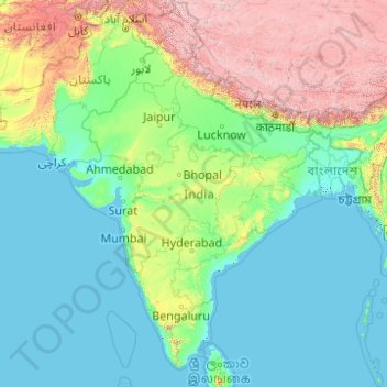
Name: India topographic map, elevation, terrain.
Location: India (6.55312 67.95444 35.67455 97.39556)
Average elevation: 1,017 m
Minimum elevation: -2 m
Maximum elevation: 7,656 m
Make a donation
Other topographic maps
Click on a map to view its topography, its elevation and its terrain.
Quezon City
Founded as a pueblo by Saint Pedro Bautista in 1590, San Francisco del Monte may be considered Quezon City's oldest district. The original land area of the old town of San Francisco del Monte was approximately2.5 square kilometres (1.0 sq mi) and covered parts of what is currently known as Project 7 and 8 and…
Average elevation: 57 m
Boise
United States of America > Idaho > Boise
Boise (/ˈbɔɪsi/ (listen)) is the capital and most populous city of the U.S. state of Idaho, and is the county seat of Ada County. Located on the Boise River in southwestern Idaho, it is 41 miles (66 km) east of the Oregon border, and 110 miles (177 km) north of the Nevada border. The downtown area's…
Average elevation: 1,040 m
Make a donation
Bacolod
Bacólod (English: Bacolod), is derived from bakólod (Old Spelling: bacólod), the Old Hiligaynon (Old Ilonggo) (Old Spelling: Ylongo and Ilongo) word for a "hill, turtle, mound, rise, hillock, down, any small eminence or elevation", since the resettlement was founded on a stony, hilly area, now the barangay…
Average elevation: 49 m
Mandaue
It is one of the two (the other one being the municipality of Consolacion) local government units located within the mainland Metro Cebu where the elevation of land is less than 100 m (330 ft).
Average elevation: 109 m
Baguio
In 1903, Filipinos, Japanese and Chinese workers were hired to build Kennon Road, the first road directly connecting Baguio with the lowlands of La Union and Pangasinan. Before this, the only road to Benguet was Naguilian Road, and it was largely a horse trail at higher elevations. Camp John Hay was…
Average elevation: 881 m
Make a donation
San Juan
"San Juan" is a contraction of the city's traditional name of "San Juan del Monte" (lit. 'Saint John of the Mountain'). As with numerous other places in the Philippines, the name combines a patron saint and a toponym; in this case Saint John the Baptist with the locale's hilly terrain and relatively higher…
Average elevation: 35 m
Calapan
Philippines > Oriental Mindoro
The overall land characteristic is a wide plain with rivers, interspersed with wetlands at the seacoast periphery. The highest elevation is 187 m (614 ft) above sea level at Bulusan Hill, a 6-kilometre (3.7 mi) long landform east of the city, which interrupts the mostly flat terrain north-east of the…
Average elevation: 40 m
Tagaytay
The southern and eastern portions of Tagaytay are covered by hills and mountains which is generally forests, pine trees and open grasslands. The city lies along Tagaytay Ridge, a ridge stretching about 32 kilometres (20 mi) from Mount Batulao in the west to Mount Sungay in the east with elevations averaging…
Average elevation: 229 m
Make a donation
Antipolo
Its higher elevation than that of Metro Manila affords it a scenic view of the metropolis, especially at night. Its locally grown mangoes and cashews are popular among tourists, as well as suman – a local delicacy made out of glutinous rice. The Hinulugang Taktak National Park, which was once a popular…
Average elevation: 125 m
Make a donation
Legazpi
Legazpi's topography is generally plain on the northeastern areas, with slopes ranging from five to fifteen degrees. The southern areas have mostly rolling to hilly terrain. In the city's coastal areas, the terrain varies from plain (north) to hilly (south). Legazpi is criss-crossed by several rivers including…
Average elevation: 150 m
Trece Martires
The city of Trece Martires is characterised with ground elevation ranging from 30m to nearly 400m. Its ground slope ranges from 0.5 to 2%.
Average elevation: 150 m
Make a donation
Make a donation
Vigan
Vigan is situated in a Quaternary Age sedimentary plain called the Vigan-Bantay Plain which is part of the Ilocos coastal plain. The Vigan-Bantay Plain is bounded on the east by a moderately rugged Miocene sediments consisting of interbedded sandstones and shale to very rugged Meta-volcanics and Meta sediment…
Average elevation: 63 m
Make a donation
Lake Sebu
The placid lake of Lake Sebu can be found in Allah Valley near the municipality of Surallah, South Cotabato. Surrounded by rolling hills and mountains covered with thick rain forest, the lake has an area of 361.124 hectares (892.36 acres), with an elevation of approximately 1,000 metres (3,300 ft).
Average elevation: 750 m
Make a donation
Valencia
The city's topography is characterized as flat to undulating hills with extensive plateaus and mountainous areas and cliffs on both eastern and western portions bounding the municipality of San Fernando on the east and the municipality of Talakag on the west. Its highest point is Mount Kalatungan in the…
Average elevation: 566 m
Sorsogon City
Sorsogon City covers a land area of 31,292 hectares (120.82 sq mi). It is at the southernmost tip of the Bicol Peninsula and of Luzon Island. The city is bounded by Castilla in the west, Manito in the northwest, Albay Gulf in the north, Prieto Diaz in the east, Gubat in the southeast, Casiguran in the…
Average elevation: 89 m
Mandaluyong
Another claims that the Spaniards named the place based on the report of a navigator named Acapulco, who saw the rolling hills frequently being lashed at by daluyong (“big waves from the sea”). This seems to confirm traditional pre-Hispanic stories that giant waves from the sea would meet the adjoining…
Average elevation: 33 m
Make a donation
Make a donation
Make a donation
Daraga
67.3% of the total municipal land area has a predominantly low elevation of up to 100 metres (330 ft). The surface terrain is generally characterized by combination of level to nearly level areas, gentle to undulating areas and undulating to rolling areas.
Average elevation: 76 m
Malolos
Malolos is relatively flat of about 0.81% to a gently sloping of 2.17%. The slope of the land descends towards west, southwest to southern direction. The highest land elevation is at about 6.0 meters above sea level while the lowest is only half a meter below sea level. A network of natural waterways and…
Average elevation: 6 m
Make a donation
Make a donation
Bantay
It has an average elevation of 100 meters (328.08 feet), with a land area of 7,660 hectares (18,900 acres). It is an elevated and hilly municipality but some barangays, especially those near creeks, are prone to flooding during heavy typhoons.
Average elevation: 8 m
Make a donation
Mount Piapayungan
Mount Ragang, also called Mount Piapayungan and Blue Mountain by the local people, is an active stratovolcano on Mindanao island in the Philippines. With an elevation of 2,815 metres (9,236 ft), it is the seventh highest mountain in the Philippines and the highest point in the Lanao del Sur province.
Average elevation: 2,394 m
Make a donation
Make a donation
Make a donation
Make a donation
Make a donation
Mount Pinatubo
Even before the 1991 eruption, Mount Pinatubo had little topographic prominence: it was 1,745 m (5,725 ft) above sea level, only about 600 m (2,000 ft) above nearby plains, and only about 200 m (660 ft) higher than surrounding peaks, which largely obscured it from view. It is part of a chain of volcanoes which…
Average elevation: 1,047 m
Make a donation
Make a donation
Make a donation
Santa Barbara
The topography of Santa Barbara varies from slightly rolling hills to almost flat or gradually inclined plains, sliced by Tigum River at its centremost, which flows from the north-west to the southeast and the Aganan River in the southern section.
Average elevation: 34 m
Make a donation
Bingawan
Bingawan is relatively dry from November to April and wet during the rest of the year. The maximum rain periods are not very heavy with a short dry season lasting from one to three months. The climate is influenced by the southeast monsoons, one of the principal air streams affecting the country. Local…
Average elevation: 64 m
Mount Halcon
Philippines > Oriental Mindoro
Mount Halcon (Filipino: Bundok Halcon) and (Spanish: Monte Halcón) is the highest mountain in Mindoro. According to the new data released by Oriental Mindoro peakvisor as of 2022, it has an elevation of 2,616 metres (8,583 ft) above sea level, higher than the previous estimates of 2,586 m (8,484 ft) although…
Average elevation: 2,121 m
Mount Kitanglad
Philippines > Bukidnon > Impasugong
Due to its high elevation, several communications and broadcasting companies constructed relay stations at the summit.
Average elevation: 2,393 m
Make a donation
Make a donation