Geolocate

Balangiga topographic map

Interactive map

Click on the map to display elevation.

About this map

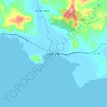
Name: Balangiga topographic map, elevation, terrain.

Location: Balangiga, Eastern Samar, Eastern Visayas, 6812, Philippines (11.06745 125.34745 11.14745 125.42745)

Average elevation: 27 m

Minimum elevation: -1 m

Maximum elevation: 260 m

Other topographic maps

Click on a map to view its topography, its elevation and its terrain.

Homonhon Island

Philippines > Eastern Samar > Culasi

Average elevation: 27 m

Tikling

Philippines > Eastern Samar

Average elevation: 0 m

Calicoan Island

Philippines > Eastern Samar > Ngolos

Average elevation: 4 m

Homonhon Island

Philippines > Eastern Samar > Cagusu-an

Average elevation: 27 m

Manicani Island

Philippines > Eastern Samar > Banaag

Average elevation: 18 m

Hilabaan

Philippines > Eastern Samar

Average elevation: 1 m

Borongan City

Philippines > Eastern Samar

Average elevation: 11 m

Suluan Island

Philippines > Eastern Samar > Suluan

Average elevation: 12 m

Jipapad

Philippines > Eastern Samar

Average elevation: 110 m

Homonhon Island

Philippines > Eastern Samar > Habag

Average elevation: 27 m

Oras

Philippines > Eastern Samar > Jipapad

Average elevation: 37 m