
Old Toronto topographic map
Interactive map
Click on the map to display elevation.
About this map
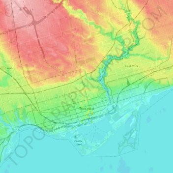
Name: Old Toronto topographic map, elevation, terrain.
Location: Old Toronto, Toronto, Golden Horseshoe, Ontario, Canada (43.61038 -79.49282 43.73602 -79.27851)
Average elevation: 116 m
Minimum elevation: 68 m
Maximum elevation: 201 m
Despite its deep ravines, Toronto is not remarkably hilly, but its elevation does increase steadily away from the lake. Elevation differences range from 76.5 metres (251 ft) above sea level at the Lake Ontario shore to 209 m (686 ft) above sea level near the York University grounds in the city's north end at the intersection of Keele Street and Steeles Avenue. There are occasional hilly areas; in particular, midtown Toronto has a number of sharply sloping hills. Lake Ontario remains occasionally visible from the peaks of these ridges as far north as Eglinton Avenue, 7 to 8 kilometres (4.3 to 5.0 mi) inland.
Other topographic maps
Click on a map to view its topography, its elevation and its terrain.
Carling Township
Canada > Ontario > Parry Sound District
Carling Township, Parry Sound District, Central Ontario, Ontario, P0G 1G0, Canada
Average elevation: 180 m
The Archipelago Township
Canada > Ontario > Parry Sound District
The Archipelago Township, Parry Sound District, Central Ontario, Ontario, Canada
Average elevation: 204 m
Shebeshekong Lake
Canada > Ontario > Parry Sound District > Carling Township
Shebeshekong Lake, Carling Township, Parry Sound District, Central Ontario, Ontario, Canada
Average elevation: 205 m
South River
Canada > Ontario > Parry Sound District
South River, Parry Sound District, Central Ontario, Ontario, Canada
Average elevation: 352 m
North Stormont
Canada > Ontario > Stormont, Dundas and Glengarry Counties
North Stormont, Stormont, Dundas and Glengarry Counties, Eastern Ontario, Ontario, Canada
Average elevation: 82 m
Unorganized North Algoma
Canada > Ontario > Algoma District
Unorganized North Algoma, Algoma District, Northeastern Ontario, Ontario, Canada
Average elevation: 319 m
Port Rowan
Canada > Ontario > Norfolk County
Port Rowan, Norfolk County, Ontario, N0E 1M0, Canada
Average elevation: 182 m
Collingwood
Canada > Ontario > Simcoe County
Collingwood, Simcoe County, Central Ontario, Ontario, Canada
Average elevation: 190 m
Frontenac County
Frontenac County, Eastern Ontario, Ontario, Canada
Average elevation: 169 m
Parry Sound District
Parry Sound District, Central Ontario, Ontario, Canada
Average elevation: 237 m
Leeds and Grenville
Canada > Ontario > Leeds and Grenville Counties
Leeds and Grenville, Leeds and Grenville Counties, Eastern Ontario, Ontario, Canada
Average elevation: 146 m
Keewatin Park
Canada > Ontario > Durham Region > Oshawa
Keewatin Park, 105, Harmony, Oshawa, Durham Region, Golden Horseshoe, Ontario, Canada
Average elevation: 117 m
Hastings County
Hastings County, Central Ontario, Ontario, Canada
Average elevation: 288 m
Rainy River District
Rainy River District, Northwestern Ontario, Ontario, Canada
Average elevation: 406 m
Kenora District
Kenora District, Northwestern Ontario, Ontario, Canada
Average elevation: 208 m
Halton Hills
Canada > Ontario > Halton Region
Halton Hills, Halton Region, Golden Horseshoe, Ontario, L7G 5W1, Canada
Average elevation: 287 m
Milligan's Pond
Milligan's Pond, Barrie, Central Ontario, Ontario, Canada
Average elevation: 238 m
Kemptville
Canada > Ontario > Leeds and Grenville Counties > North Grenville
Kemptville, North Grenville, Leeds and Grenville Counties, Eastern Ontario, Ontario, K0G 1J0, Canada
Average elevation: 97 m
Chatham
Canada > Ontario > Chatham-Kent
Chatham, Chatham-Kent, Southwestern Ontario, Ontario, N7M 2G6, Canada
Average elevation: 184 m
Jack's Ridge
Canada > Ontario > Parry Sound District > Unorganized Centre Parry Sound
Jack's Ridge, Unorganized Centre Parry Sound, Parry Sound District, Central Ontario, Ontario, Canada
Average elevation: 254 m
Owen Sound
Canada > Ontario > Grey County > Owen Sound
Owen Sound, Grey County, Southwestern Ontario, Ontario, Canada
Average elevation: 222 m
Timmins
Canada > Ontario > Cochrane District > Timmins
Timmins, Cochrane District, Northeastern Ontario, Ontario, Canada
Average elevation: 302 m
Elliot Lake
Canada > Ontario > Algoma District > Elliot Lake
Elliot Lake, Algoma District, Northeastern Ontario, Ontario, Canada
Average elevation: 342 m
Lion's Head Provincial Nature Reserve
Canada > Ontario > Northern Bruce Peninsula
Lion's Head Provincial Nature Reserve, McKague Road, Northern Bruce Peninsula, Bruce County, Southwestern Ontario, Ontario, Canada
Average elevation: 206 m
Halton Region
Halton Region, Golden Horseshoe, Ontario, Canada
Average elevation: 226 m
Brampton
Canada > Ontario > Peel Region
Brampton, Peel Region, Golden Horseshoe, Ontario, Canada
Average elevation: 223 m
Waterloo
Canada > Ontario > Region of Waterloo
Waterloo, Region of Waterloo, Ontario, Canada
Average elevation: 341 m
Pleasant View Survey
Canada > Ontario > Hamilton > Pleasant View Survey
Pleasant View Survey, Hamilton, Ontario, L9H 5M4, Canada
Average elevation: 145 m
Hawkesbury
Canada > Ontario > Hawkesbury
Hawkesbury, Prescott and Russell Counties, Eastern Ontario, Ontario, Canada
Average elevation: 53 m
Grand River
Grand River, Wellington County, Southwestern Ontario, Ontario, N0B 2V0, Canada
Average elevation: 300 m
Manitoulin District
Manitoulin District, Northeastern Ontario, Ontario, Canada
Average elevation: 213 m
Kingcome Island
Kingcome Island, Thunder Bay District, Northwestern Ontario, Ontario, Canada
Average elevation: 193 m
Niagara Escarpment
Canada > Ontario > Burlington
Niagara Escarpment, Wetland Trail, Tyandaga, Nelson, Burlington, Halton Region, Ontario, L0R 2H7, Canada
Average elevation: 216 m
Freedom Island
Canada > Ontario > The Archipelago
Freedom Island, The Archipelago, Parry Sound District, Ontario, Canada
Average elevation: 201 m
Thunder Bay District
Thunder Bay District, Northwestern Ontario, Ontario, Canada
Average elevation: 313 m
Cumberland
Canada > Ontario > Ottawa > Cumberland
Cumberland, Ottawa, Eastern Ontario, Ontario, Canada
Average elevation: 75 m
Alta Vista
Alta Vista, (Old) Ottawa, Ottawa, Ontario, Canada
Average elevation: 77 m
Teardrop Lake
Teardrop Lake, La Cloche Silhouette Trail, Killarney, Sudbury District, Ontario, P0M 2A0, Canada
Average elevation: 272 m
Mayne Island
Canada > Ontario > The Archipelago
Mayne Island, The Archipelago, Parry Sound District, Ontario, Canada
Average elevation: 194 m
The Blue Mountains
Canada > Ontario > The Blue Mountains
The Blue Mountains, Grey County, Southwestern Ontario, Ontario, Canada
Average elevation: 229 m