
Thank you for supporting this site ❤️
Make a donation
Make a donation
Parry Sound District topographic map
Click on the map to display elevation.
Thank you for supporting this site ❤️
Make a donation
Make a donation
About this map
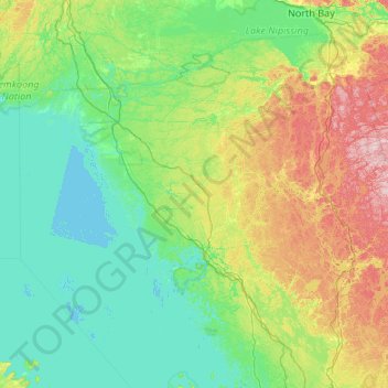
Name: Parry Sound District topographic map, elevation, terrain.
Location: Parry Sound District, Central Ontario, Ontario, Canada (44.97331 -81.07683 46.24226 -78.93048)
Average elevation: 237 m
Minimum elevation: 172 m
Maximum elevation: 543 m
Thank you for supporting this site ❤️
Make a donation
Make a donation
Other topographic maps
Click on a map to view its topography, its elevation and its terrain.
Thank you for supporting this site ❤️
Make a donation
Make a donation
Thank you for supporting this site ❤️
Make a donation
Make a donation