
Thank you for supporting this site ❤️
Make a donation
Make a donation
Wellington County topographic map
Click on the map to display elevation.
Thank you for supporting this site ❤️
Make a donation
Make a donation
About this map
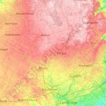
Name: Wellington County topographic map, elevation, terrain.
Location: Wellington County, Ontario, Canada (43.38696 -80.99150 44.02598 -79.96904)
Average elevation: 395 m
Minimum elevation: 249 m
Maximum elevation: 526 m
Thank you for supporting this site ❤️
Make a donation
Make a donation
Other topographic maps
Click on a map to view its topography, its elevation and its terrain.
Thank you for supporting this site ❤️
Make a donation
Make a donation
Thank you for supporting this site ❤️
Make a donation
Make a donation