
Palanan topographic map
Click on the map to display elevation.
About this map
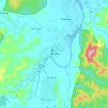
Name: Palanan topographic map, elevation, terrain.
Location: Palanan, Isabela, Cagayan Valley, 3334, Philippines (17.02287 122.38927 17.10287 122.46927)
Average elevation: 45 m
Minimum elevation: -3 m
Maximum elevation: 262 m
Other topographic maps
Click on a map to view its topography, its elevation and its terrain.