Geolocate

Nagaland topographic map

Interactive map

Click on the map to display elevation.

About this map

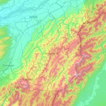
Name: Nagaland topographic map, elevation, terrain.

Location: Nagaland, Inde (25.19870 93.32670 27.03580 95.24238)

Average elevation: 824 m

Minimum elevation: 67 m

Maximum elevation: 3,721 m

Il est parcouru par les rivières Dhansiri, Doyang, Dikhu, Milak, Zungki et Tizu. Le point culminant est le Saramati, à 3 841 m d'altitude.

Other topographic maps

Click on a map to view its topography, its elevation and its terrain.

Tizit

Inde > Nagaland > Mon

Tizit, Mon, Nagaland, 798602, Inde

Average elevation: 236 m

Peren

Inde > Nagaland

Peren, Nagaland, 797101, Inde

Average elevation: 1,030 m

Kiphire

Inde > Nagaland

Kiphire, Nagaland, Inde

Average elevation: 1,502 m

Khonoma

Inde > Nagaland > Khonoma

Khonoma, Sechu-Zubza, Kohima, Nagaland, 797002, Inde

Average elevation: 1,627 m

Dimapur

Inde > Nagaland > Dimapur

Dimapur, Dimapur Sadar, Dimapur, Nagaland, 797112, Inde

Average elevation: 204 m

Kohīma

Inde > Nagaland

Kohīma, Kohima, Nagaland, Inde

Average elevation: 1,026 m

Chare

Inde > Nagaland > Chare

Chare, Tuensang District, Tuensang, Nagaland, Inde

Average elevation: 764 m