Geolocate

Kiphire topographic map

Interactive map

Click on the map to display elevation.

About this map

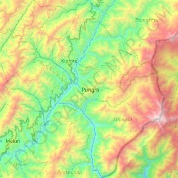
Name: Kiphire topographic map, elevation, terrain.

Location: Kiphire, Nagaland, Inde (25.59119 94.56969 26.03937 95.05168)

Average elevation: 1,502 m

Minimum elevation: 409 m

Maximum elevation: 3,821 m

Other topographic maps

Click on a map to view its topography, its elevation and its terrain.

Tizit

Inde > Nagaland > Mon

Tizit, Mon, Nagaland, 798602, Inde

Average elevation: 236 m

Peren

Inde > Nagaland

Peren, Nagaland, 797101, Inde

Average elevation: 1,030 m

Khonoma

Inde > Nagaland > Khonoma

Khonoma, Sechu-Zubza, Kohima, Nagaland, 797002, Inde

Average elevation: 1,627 m

Dimapur

Inde > Nagaland > Dimapur

Dimapur, Dimapur Sadar, Dimapur, Nagaland, 797112, Inde

Average elevation: 204 m

Kohīma

Inde > Nagaland

Kohīma, Kohima, Nagaland, Inde

Average elevation: 1,026 m

Nagaland

Inde > Nagaland

Nagaland, Inde

Average elevation: 824 m

Chare

Inde > Nagaland > Chare

Chare, Tuensang District, Tuensang, Nagaland, Inde

Average elevation: 764 m