
Make a donation
Western Development Region topographic map
Click on the map to display elevation.
Make a donation
Western Development Region
The Western Development Region (Nepali: पश्चिमाञ्चल विकास क्षेत्र, Pashchimānchal Bikās Kshetra) was one of Nepal's five development regions. It was located in the west-central part of the country, with its headquarters located in Pokhara. This Development Region was divided into three parts, from south to north in order of increasing altitude: Terai, Hilly and Himalayan. Mustang, Damodar, Peri, Thaple, Ganesh are among the major ranges of the Himalayas.
Make a donation
About this map
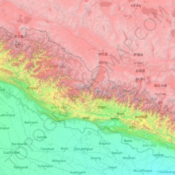
Name: Western Development Region topographic map, elevation, terrain.
Location: Western Development Region, Nepal (26.05710 80.90564 31.25710 86.10564)
Average elevation: 2,742 m
Minimum elevation: 44 m
Maximum elevation: 7,925 m
Make a donation
Other topographic maps
Click on a map to view its topography, its elevation and its terrain.
Bagmati Province
Bagmati Province has an area of 20,300 km2 which is about 13.79% of the total area of Nepal. The elevation of the province ranges from 141 m at Golaghat in Chitwan District to 7,422m at Ganesh Himal. The province has an altitude low enough to support deciduous, coniferous, and alpine forests and woodlands.…
Average elevation: 2,234 m
Make a donation
Pokhara
Nepal > Gandaki Province > Kaski
Pokhara (Nepali: पोखरा, Nepali pronunciation: [ˈpokʰʌɾa]) is a metropolitan city in Nepal, which serves as the capital of Gandaki Province. It is the second most populous city of Nepal after Kathmandu, with 518,452 inhabitants living in 101,669 households in 2021. It is the country's largest…
Average elevation: 1,203 m