
Make a donation
Bagmati Province topographic map
Click on the map to display elevation.
Make a donation
Bagmati Province
Bagmati Province has an area of 20,300 km2 which is about 13.79% of the total area of Nepal. The elevation of the province ranges from 141 m at Golaghat in Chitwan District to 7,422m at Ganesh Himal. The province has an altitude low enough to support deciduous, coniferous, and alpine forests and woodlands. 27.29% land is covered by forest. The temperature varies with altitude. There are 10 sub-basins and 33 major rivers flowing through the province. The longest river is the Sunkoshi measuring 160.19 km.
Make a donation
About this map
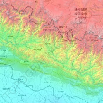
Name: Bagmati Province topographic map, elevation, terrain.
Location: Bagmati Province, Nepal (26.91907 83.91936 28.38583 86.57265)
Average elevation: 2,234 m
Minimum elevation: 54 m
Maximum elevation: 8,647 m
Make a donation
Other topographic maps
Click on a map to view its topography, its elevation and its terrain.
Western Development Region
The Western Development Region (Nepali: पश्चिमाञ्चल विकास क्षेत्र, Pashchimānchal Bikās Kshetra) was one of Nepal's five development regions. It was located in the west-central part of the country, with its headquarters located in Pokhara. This Development Region…
Average elevation: 2,742 m
Kathmandu
Nepal > Bagmati Province > Kathmandu
Kathmandu, officially the Kathmandu Metropolitan City, is the seat of federal government and the most populous city in Nepal. As of the 2021 Nepal census, there were 845,767 inhabitants living in 105,649 households and approximately 4 million people in its surrounding agglomeration. It is located in the…
Average elevation: 1,538 m
Lukla
Nepal > Koshi Province > Solukhumbu
Lukla contains a small airport serving the region, and a variety of shops and lodges catering to tourists and trekkers, providing western-style meals and trail supplies. From Lukla, travellers need two days to reach the village of Namche Bazaar, an altitude-acclimatization stop for those continuing on. In…
Average elevation: 2,996 m
Make a donation