
San Cristóbal de las Casas topographic map
Interactive map
Click on the map to display elevation.
About this map
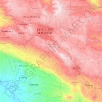
Name: San Cristóbal de las Casas topographic map, elevation, terrain.
Location: San Cristóbal de las Casas, Chiapas, Mexiko (16.53890 -92.72028 16.78977 -92.33981)
Average elevation: 1,796 m
Minimum elevation: 399 m
Maximum elevation: 2,879 m
Other topographic maps
Click on a map to view its topography, its elevation and its terrain.
Lacanjá Chansayab
Lacanjá Chansayab, Ocosingo, Chiapas, 29550, Mexiko
Average elevation: 335 m
San Juan Chamula
San Juan Chamula, Chamula, Chiapas, Mexiko
Average elevation: 2,297 m