
Palenque topographic map
Interactive map
Click on the map to display elevation.
About this map
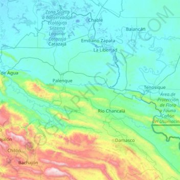
Name: Palenque topographic map, elevation, terrain.
Location: Palenque, Chiapas, 29960, Mexiko (17.06701 -92.35019 17.83947 -91.26041)
Average elevation: 314 m
Minimum elevation: -7 m
Maximum elevation: 2,102 m
Other topographic maps
Click on a map to view its topography, its elevation and its terrain.
Lacanjá Chansayab
Lacanjá Chansayab, Ocosingo, Chiapas, 29550, Mexiko
Average elevation: 335 m
San Juan Chamula
San Juan Chamula, Chamula, Chiapas, Mexiko
Average elevation: 2,297 m
San Cristóbal de las Casas
San Cristóbal de las Casas, Chiapas, Mexiko
Average elevation: 1,796 m