
Corcuera topographic map
Click on the map to display elevation.
About this map
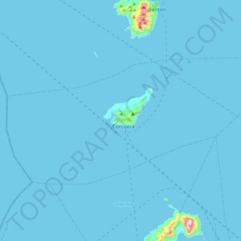
Name: Corcuera topographic map, elevation, terrain.
Location: Corcuera, Romblon, Mimaropa, 5514, Philippines (12.70334 121.88032 12.87889 122.22796)
Average elevation: 8 m
Minimum elevation: 0 m
Maximum elevation: 653 m
Other topographic maps
Click on a map to view its topography, its elevation and its terrain.
Mount Guiting-Guiting
Philippines > Romblon > Cajidiocan
Mount Guiting-Guiting or G2 is the highest mountain in the province of Romblon, located in Sibuyan Island, in the Philippines, with an elevation of 6,752 ft (2,058 m) above sea level. Its steep slopes and jagged peak, have earned it the reputation, as one of the most difficult and technically most challenging…
Average elevation: 1,478 m
roadside view of Mt.Guiting-Guiting
Philippines > Romblon > Magdiwang > Sitio Agnonoc
Average elevation: 10 m