
Ávila topographic map
Interactive map
Click on the map to display elevation.
About this map
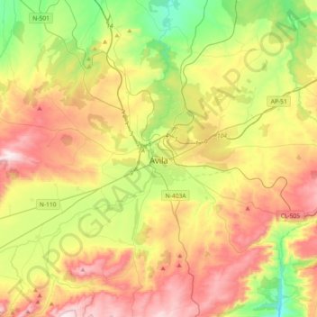
Name: Ávila topographic map, elevation, terrain.
Location: Ávila, Castile and León, Spain (40.56076 -4.81645 40.75367 -4.45361)
Average elevation: 1,157 m
Minimum elevation: 840 m
Maximum elevation: 1,555 m
Ávila's position results in a temperate Mediterranean climate (Csb, according to the Köppen climate classification), with warm summers and chilly winters with snowfalls, bordering on a cold semi-arid climate (BSk). The hottest month, July, has an average temperature of 20.6 °C (69 °F), and the coldest month, January, has an average of 3.0 °C (37 °F). The average annual precipitation is 416 mm (16.38 in). Annual rainfall is low compared to surrounding areas, implying that it lies in a rain shadow. The Adaja is dry for several months of the year and the town has historically had water supply problems. Ávila has the coldest winter low temperatures of the Spanish provincial capital cities, thanks to its high altitude (1,132 metres (3,714 ft) above sea level).
Other topographic maps
Click on a map to view its topography, its elevation and its terrain.
San Justo
San Justo, Zamora, Castile and León, Spain
Average elevation: 1,332 m
Real Sitio de San Ildefonso
Real Sitio de San Ildefonso, Segovia, Castile and León, Spain
Average elevation: 1,562 m
San Juan del Monte
San Juan del Monte, Burgos, Castile and León, Spain
Average elevation: 872 m
Buenavista
Buenavista, Salamanca, Castile and León, Spain
Average elevation: 936 m
Santa Inés
Spain > Castile and León > Santa Inés
Santa Inés, Burgos, Castile and León, Spain
Average elevation: 896 m
San José
Spain > Castile and León > Merindad de Sotoscueva
San José, Merindad de Sotoscueva, Burgos, Castile and León, Spain
Average elevation: 700 m
Douro
Douro, Valladolid, Castile and León, 09417, Spain
Average elevation: 698 m
Riaño
Spain > Castile and León > Riaño
Riaño, Castile and León, 24900, Spain
Average elevation: 1,140 m
La Tala
Spain > Castile and León > La Tala
La Tala, Comarca de Guijuelo, Salamanca, Castile and León, Spain
Average elevation: 946 m
Lanuza
Spain > Castile and León > Fresneda de la Sierra Tirón
Lanuza, Fresneda de la Sierra Tirón, Montes de Oca, Burgos, Castile and León, 26288, Spain
Average elevation: 1,215 m
Canales
Spain > Castile and León > Canales
Canales, La Moraña, Ávila, Castile and León, Spain
Average elevation: 862 m
Salamanca
Spain > Castile and León > Salamanca
Salamanca, Campo de Salamanca, Salamanca, Castile and León, Spain
Average elevation: 812 m
Arapiles
Spain > Castile and León > Arapiles
Arapiles, Campo de Salamanca, Salamanca, Castile and León, Spain
Average elevation: 842 m
El Espinar
Spain > Castile and León > El Espinar
El Espinar, Segovia, Castile and León, Spain
Average elevation: 1,324 m
Cerro de la Estrella
Spain > Castile and León > Cebreros
Cerro de la Estrella, Cebreros, Ávila, Castile and León, 05260, Spain
Average elevation: 1,006 m
Tanja
Spain > Castile and León > Humada
Tanja, Humada, Páramos, Burgos, Castile and León, Spain
Average elevation: 986 m
Contreras
Spain > Castile and León > Contreras
Contreras, Sierra de la Demanda, Burgos, Castile and León, Spain
Average elevation: 1,089 m
Pardo
Spain > Castile and León > Espinosa de los Monteros
Pardo, Espinosa de los Monteros, Las Merindades, Burgos, Castile and León, Spain
Average elevation: 1,184 m
Atua
Spain > Castile and León > Condado de Treviño
Atua, Condado de Treviño, Ebro, Burgos, Castile and León, Spain
Average elevation: 629 m
Nicasia
Spain > Castile and León > Cuéllar
Nicasia, Cuéllar, Segovia, Castile and León, 40200, Spain
Average elevation: 809 m
Mudá
Spain > Castile and León > Mudá > Mudá
Mudá, Campoo, Castile and León, Spain
Average elevation: 1,051 m
Pico Almanzor
Spain > Castile and León > Candeleda
Pico Almanzor, Candeleda, Comarca de Arenas de San Pedro, Ávila, Castile and León, Spain
Average elevation: 2,159 m
Oeste
Spain > Castile and León > Salamanca
Oeste, Salamanca, Campo de Salamanca, Salamanca, Castile and León, Spain
Average elevation: 813 m
Palencia
Spain > Castile and León > Palencia
Palencia, Castile and León, Spain
Average elevation: 794 m
La Pililla
Spain > Castile and León > Cebreros
La Pililla, Cebreros, Ávila, Castile and León, 05250, Spain
Average elevation: 901 m
La Maya
Spain > Castile and León > La Maya
La Maya, Tierra de Alba, Salamanca, Castile and León, Spain
Average elevation: 850 m
Milagros
Milagros, Burgos, Castile and León, 09460, Spain
Average elevation: 884 m