
Singhbhūm topographic map
Interactive map
Click on the map to display elevation.
About this map
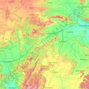
Name: Singhbhūm topographic map, elevation, terrain.
Location: Singhbhūm, Pashchimi Singhbhum, Jharkhand, Inde (21.80000 84.80000 23.20000 86.20000)
Average elevation: 379 m
Minimum elevation: 120 m
Maximum elevation: 1,089 m
Other topographic maps
Click on a map to view its topography, its elevation and its terrain.
Rāmnagartola
Rāmnagartola, Pakaur, Pakur District, Jharkhand, 816107, Inde
Average elevation: 34 m
Sahibganj (block)
Sahibganj (block), Sahibganj District, Jharkhand, 816109, Inde
Average elevation: 60 m