
Make a donation
Artemisa topographic map
Click on the map to display elevation.
Make a donation
Artemisa
The maximum elevation in the province is Guajaibon peak (700 meters), and is located near N 22 47' 19" W 83 21' 52" in Sierra del Rosario range.
Make a donation
About this map
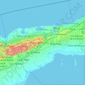
Name: Artemisa topographic map, elevation, terrain.
Location: Artemisa, Cuba (22.34547 -83.44916 23.30798 -82.39527)
Average elevation: 35 m
Minimum elevation: -2 m
Maximum elevation: 664 m
Make a donation
Other topographic maps
Click on a map to view its topography, its elevation and its terrain.
Havana
Cuba > Havana > La Habana Vieja
There are low hills on which the city lies rise gently from the waters of the straits. A noteworthy elevation is the 200-foot-high (60-meter) limestone ridge that slopes up from the east and culminates in the heights of La Cabaña and El Morro, the sites of Spanish fortifications overlooking the eastern bay.…
Average elevation: 30 m
Make a donation
Make a donation
Make a donation
Make a donation
Make a donation
Make a donation
Make a donation
Make a donation
Havana
Cuba > Havana > La Habana Vieja
There are low hills on which the city lies rise gently from the waters of the straits. A noteworthy elevation is the 200-foot-high (60-meter) limestone ridge that slopes up from the east and culminates in the heights of La Cabaña and El Morro, the sites of Spanish fortifications overlooking the eastern bay.…
Average elevation: 30 m
Make a donation
Make a donation
Make a donation
Make a donation