
Thank you for supporting this site ❤️
Make a donation
Make a donation
Vega Larga topographic map
Click on the map to display elevation.
Thank you for supporting this site ❤️
Make a donation
Make a donation
About this map
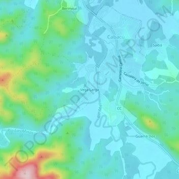
Name: Vega Larga topographic map, elevation, terrain.
Location: Vega Larga, Baracoa, Guantánamo, 97310, Cuba (20.28949 -74.50648 20.32949 -74.46648)
Average elevation: 55 m
Minimum elevation: 1 m
Maximum elevation: 317 m
Thank you for supporting this site ❤️
Make a donation
Make a donation
Other topographic maps
Click on a map to view its topography, its elevation and its terrain.