
Make a donation
Kundapura topographic map
Click on the map to display elevation.
Make a donation
About this map
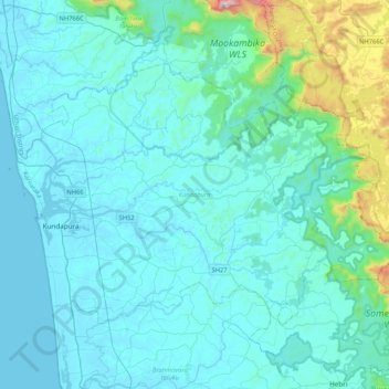
Name: Kundapura topographic map, elevation, terrain.
Location: Kundapura, Udupi District, Karnataka, India (13.52072 74.64172 13.79554 75.06127)
Average elevation: 131 m
Minimum elevation: 0 m
Maximum elevation: 1,315 m
Make a donation
Other topographic maps
Click on a map to view its topography, its elevation and its terrain.
Bengaluru
India > Karnataka > Bangalore North
Bangalore (/ˈbæŋɡəlɔːr, ˌbæŋɡəˈlɔːr/ BANG-gə-lor, -LOR), officially Bengaluru (Kannada pronunciation: [ˈbeŋgɐɭuːɾu] ; ISO: Beṁgaḷūru), is the capital and largest city of the southern Indian state of Karnataka. It has a population of more than 8 million and a metropolitan…
Average elevation: 879 m
Make a donation
Udupi
India > Karnataka > Udupi taluku
Udupi has an elevation of 27 m (89 ft) above mean sea level. The climate in Udupi is hot in summers and pleasant in winter. During summers (from March to May) the temperature reaches up to 38 °C (100 °F) and in winters (from December to February) it is usually between 32 and 20 °C (90 and 68 °F). As it is…
Average elevation: 17 m
Make a donation
Sirsi
India > Karnataka > Shirasi Taluk
Sirsi is located at 14°37′N 74°51′E / 14.62°N 74.85°E / 14.62; 74.85 (Grid Square MK74). It has an elevation ranging between 1860 feet to 2600 feet above sea level, and is situated in the heart of the Western Ghats. Sirsi is about 399 kilometres (248 mi) from Bangalore. The nearest airport is…
Average elevation: 556 m
Ankola
India > Karnataka > Ankola taluk
Ankola is located at 14°39′38″N 74°18′17″E / 14.66056°N 74.30472°E / 14.66056; 74.30472. It has an average elevation of 17 metres (56 ft). The Gangavali River (also known as Bedti) is a prominent river that flows near the town. Summer temperatures range between 30 and 35 °C (86 and 95…
Average elevation: 27 m
Make a donation
Bagalkote
India > Karnataka > Bagalakote taluk
Bagalakote, is a city in the state of Karnataka, India, which is also the headquarters of Bagalakote district. It is situated on branch of River Ghataprabha about 481 km (299 mi) northwest of state capital Bengaluru, 410 km (255 mi) southwest of Hyderabad, and about 570 km (354 mi) southeast of Mumbai. The…
Average elevation: 556 m