
Berkshire County topographic map
Interactive map
Click on the map to display elevation.
About this map
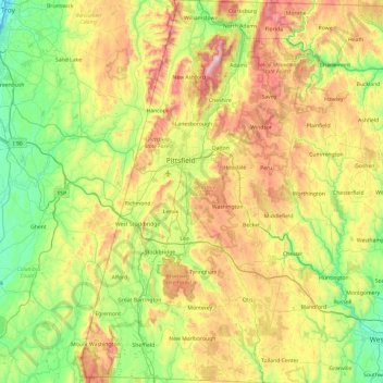
Name: Berkshire County topographic map, elevation, terrain.
Location: Berkshire County, Massachusetts, United States of America (42.03982 -73.50814 42.74585 -72.94944)
Average elevation: 359 m
Minimum elevation: 2 m
Maximum elevation: 1,061 m
Running north-south through the county are the Hoosac Range of the Berkshire Hills in the eastern part of the county and the Taconic Mountains in the western part of the county. Due to their elevation, the Berkshires attract tourists and summer residents eager to escape the heat of the lowlands.
Other topographic maps
Click on a map to view its topography, its elevation and its terrain.
North Attleborough
United States of America > Massachusetts > North Attleborough > North Attleborough
North Attleborough, Bristol County, Massachusetts, 02760, United States of America
Average elevation: 54 m
Hampshire County
United States of America > Massachusetts
Hampshire County, Massachusetts, United States of America
Average elevation: 243 m
Hampden County
United States of America > Massachusetts
Hampden County, Massachusetts, United States of America
Average elevation: 209 m
Bristol County
United States of America > Massachusetts
Bristol County, Massachusetts, United States of America
Average elevation: 26 m
Barnstable County
United States of America > Massachusetts
Barnstable County, Massachusetts, United States of America
Average elevation: 7 m