
Hampshire County topographic map
Interactive map
Click on the map to display elevation.
About this map
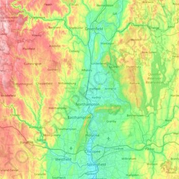
Name: Hampshire County topographic map, elevation, terrain.
Location: Hampshire County, Massachusetts, United States of America (42.18339 -73.06851 42.55604 -72.20328)
Average elevation: 243 m
Minimum elevation: 8 m
Maximum elevation: 764 m
Other topographic maps
Click on a map to view its topography, its elevation and its terrain.
North Attleborough
United States of America > Massachusetts > North Attleborough > North Attleborough
North Attleborough, Bristol County, Massachusetts, 02760, United States of America
Average elevation: 54 m
Hampden County
United States of America > Massachusetts
Hampden County, Massachusetts, United States of America
Average elevation: 209 m
Berkshire County
United States of America > Massachusetts
Berkshire County, Massachusetts, United States of America
Average elevation: 359 m
Bristol County
United States of America > Massachusetts
Bristol County, Massachusetts, United States of America
Average elevation: 26 m
Barnstable County
United States of America > Massachusetts
Barnstable County, Massachusetts, United States of America
Average elevation: 7 m