
Barnstable County topographic map
Interactive map
Click on the map to display elevation.
About this map
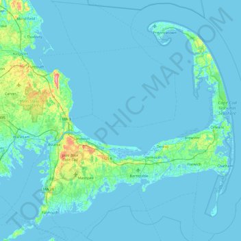
Name: Barnstable County topographic map, elevation, terrain.
Location: Barnstable County, Massachusetts, United States of America (41.48044 -70.76063 42.13365 -69.86010)
Average elevation: 7 m
Minimum elevation: -8 m
Maximum elevation: 113 m
The highest elevation in the county is 306 feet (93 m) on the summit of Pine Hill, located on Joint Base Cape Cod in Bourne. The lowest point is sea level.
Other topographic maps
Click on a map to view its topography, its elevation and its terrain.
North Attleborough
United States of America > Massachusetts > North Attleborough > North Attleborough
North Attleborough, Bristol County, Massachusetts, 02760, United States of America
Average elevation: 54 m
Hampshire County
United States of America > Massachusetts
Hampshire County, Massachusetts, United States of America
Average elevation: 243 m
Hampden County
United States of America > Massachusetts
Hampden County, Massachusetts, United States of America
Average elevation: 209 m
Berkshire County
United States of America > Massachusetts
Berkshire County, Massachusetts, United States of America
Average elevation: 359 m
Bristol County
United States of America > Massachusetts
Bristol County, Massachusetts, United States of America
Average elevation: 26 m