
Hampden County topographic map
Interactive map
Click on the map to display elevation.
About this map
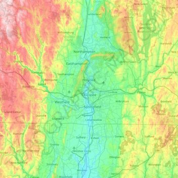
Name: Hampden County topographic map, elevation, terrain.
Location: Hampden County, Massachusetts, United States of America (41.99769 -73.07509 42.34386 -72.13501)
Average elevation: 209 m
Minimum elevation: 3 m
Maximum elevation: 677 m
Other topographic maps
Click on a map to view its topography, its elevation and its terrain.
North Attleborough
United States of America > Massachusetts > North Attleborough > North Attleborough
North Attleborough, Bristol County, Massachusetts, 02760, United States of America
Average elevation: 54 m
Hampshire County
United States of America > Massachusetts
Hampshire County, Massachusetts, United States of America
Average elevation: 243 m
Berkshire County
United States of America > Massachusetts
Berkshire County, Massachusetts, United States of America
Average elevation: 359 m
Bristol County
United States of America > Massachusetts
Bristol County, Massachusetts, United States of America
Average elevation: 26 m
Barnstable County
United States of America > Massachusetts
Barnstable County, Massachusetts, United States of America
Average elevation: 7 m